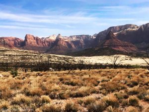
Adams Gulch in Ketchum, Idaho is a fun mountain biking trail system in a beautiful setting with great views and a backcountry feel.

Chris & Mac
We outventure to help you outventure!
For us, outventuring isn’t just about adventure. It’s about the quiet moments — the first light on a ridgeline, the sound of a creek at camp, the shared laughter when the trail gets spicy. We believe the outdoors enriches people’s lives, and we want to help more folks experience that connection. Learn more about us HERE.
Scroll down for full slideshow.
Length: 15 Trails, 33 Miles of Trails
Trailhead(s): Adams Gulch Trailhead
Elevation Gain: Depends on Chosen Route
Trail Type: Trail System
Dogs: Allowed
Difficulty: Beginner/Intermediate to Advanced
Permit Required? No
Considerations: Multi-use trail system with lots of hikers at lower elevations in system.
Season: Late Spring to Fall
Overview
Adams Gulch in Ketchum, Idaho is a fun mountain biking trail system in a beautiful setting with great views and a backcountry feel. Although there are no “beginner” trails, the trails marked intermediate are mostly threshold intermediate trails and those marked advanced receive the rating based mainly on elevation gain, as opposed to technical difficulty. In actuality, this system has something to offer to a wide range of riders, including the opportunity for some epic rides.
What makes the Adams Gulch Mountain Biking Trails Fun?
For starters, the Adams Gulch trail system sits in a beautiful area. The singletrack is mostly buff and flowy, with some rock mixed in for good measure. And the views, ah the views, are awesome, whether at low levels in the system looking up at the hills or high atop the system looking out over a sea of peaks. All this is topped off with the ability to get some backcountry riding if desired or simply stay on the mellower trails close to the trailhead.
Riding the Adams Gulch Mountain Biking Trail System
Overall, the Adams Gulch mountain biking trails are just a blast to ride. They offer a ton of that sweet, buff singetrack that makes Ketchum a coveted mountain biking destination. Within the system, there are a variety of options to make your ride as rigorous or mellow as you and those in your group desire.
For those looking for a mellow ride that falls into the low intermediate difficulty range:
Make a loop by going up Lane’s Trail and returning back on the Shady Side Trail. There is a bit of rock on the climb on Lane’s, but the grade is fairly forgiving and the views are great. Once you begin your downhill, the trail smooths out and the Shady Side Trail is just plain buff.
All tolled, you’ll cover 5.7 miles with 816′ of climbing and descent. This is a great ride for beginners looking to up their game, intermediates, and advanced riders looking for a quick spin.
If you’re looking for more of a commitment and some backcountry fun, a very popular loop and my favorite at Adams Gulch is:
Take the Shady Side Trail to Old Adams Gulch Road doubletrack, then to the Adams Gulch Loop. Take a right on the Griffin Butte Connector then right back on to the Adams Gulch Loop and stay straight on Pork Chop. Ride down Pork Chop to a left on Lane’s Trail and back to the trailhead.
The riding on this loop is solidly in the intermediate range with some good climbing, a ripping downhill on the north side of Adams Gulch Loop and Pork Chop, a great backcountry feel, and outstanding views. This ride has a bit of everything that makes Adams Gulch great. Doing this loop, you will cover 7.7 miles with 1,517′ of climbing and 1,512′ of descent.
As an alternative to descending Pork Chop, which does up the ride difficulty, many take a left on Harper’s Trail at junction with Pork Chop, then take right on the Lake Creek Connector down to Lane’s and the trailhead. This keeps the ride right in the middle of the intermediate range.
If you are seeking an epic ride, instead of taking the Griffin Butte Connector on the loop above, you can continue on the Adams Gulch Loop trail taking it all the way around and down Pork Chop. This is not a very popular route, primarily because of the amount of climbing on Adams Gulch Loop. The the first climb, alone, is 2,110′. You do get a 1,510′ descent over 5 miles on the northern leg of the loop, but you pay for that downhill. Overall, this ride from the trailhead is 15 miles with 3,500′ of climbing.
Another epic ride is the Eve’s Gulch out & back. It’s a good ride, but grueling for most mountain bikers. The ride starts with a 1,665′ climb over 4 miles with many switchbacks. You then get a 1,772′ descent over the next 3.25 miles. Being an out & back, you do it all over again in reverse on the return. The trail does have more chunk than the Adams Gulch Loop, but the advanced rating on the trail, like Adams Gulch, is still based on physical, rather than technical, difficulty.
For most riders, riding all of Eve’s Gulch is too much commitment. Many choose instead to ride to the top of the climb, then turn around and rip the descent back to Old Adams Gulch Road to Shady Side to the trailhead.
Concluding Thoughts about Adams Gulch
The variety and make-up of the trails at Adams Gulch make it an excellent ride destination. In addition to the routes I mentioned above, there are any number of other routes riders can choose, making it a great choice for groups with varying skill levels and conditioning. Combine this with the gorgeous views and Adams Gulch’s backcountry feel, and you have a winner of a mountain biking trail system. Make sure you include Adams Gulch in your itinerary for your next mountain biking trip to the Ketchum/Sun Valley area. You will be glad you did. Enjoy!
Scroll down to learn about the GEAR WE USE and OTHER OUTVENTURES in this area.
Additional Information (Click below to follow links.)
Adams Gulch Mountain Biking Trails Slideshow
(Click image to expand.)
Trailforks Interactive Trail Map:
Gear We Use for Mountain Biking
To see descriptions of the gear Chris & Mac use for mountain biking, as well as links to manufacturers and retailers offering the gear for sale, please CLICK HERE.

Articles About Other Regional Outventures
SAFETY DISCLAIMER: The activities discussed in this website are outdoor activities and, as such, have inherent risks to which participants are exposed. It is not the intent of this website, nor is it possible due to the variability of weather, terrain, equipment, and experience, to detail all of those risks. The information contained in this site is informational, but not instructive nor exhaustive. It is the sole responsibility of the user to ensure he/she is in good health, fully prepared, and fully informed as to dangers before undertaking any of the activities discussed in this website and the user does so at his/her own risk. The user understands that by using this website he/she acknowledges and accepts all risks associated with use of information from this website and participation in any particular activity addressed herein. Please see “Terms of Use” for additional information.
Want to share this article with your friends? Click on the share button below:
Want more?
Get the latest outventure updates by following us on social media . . .