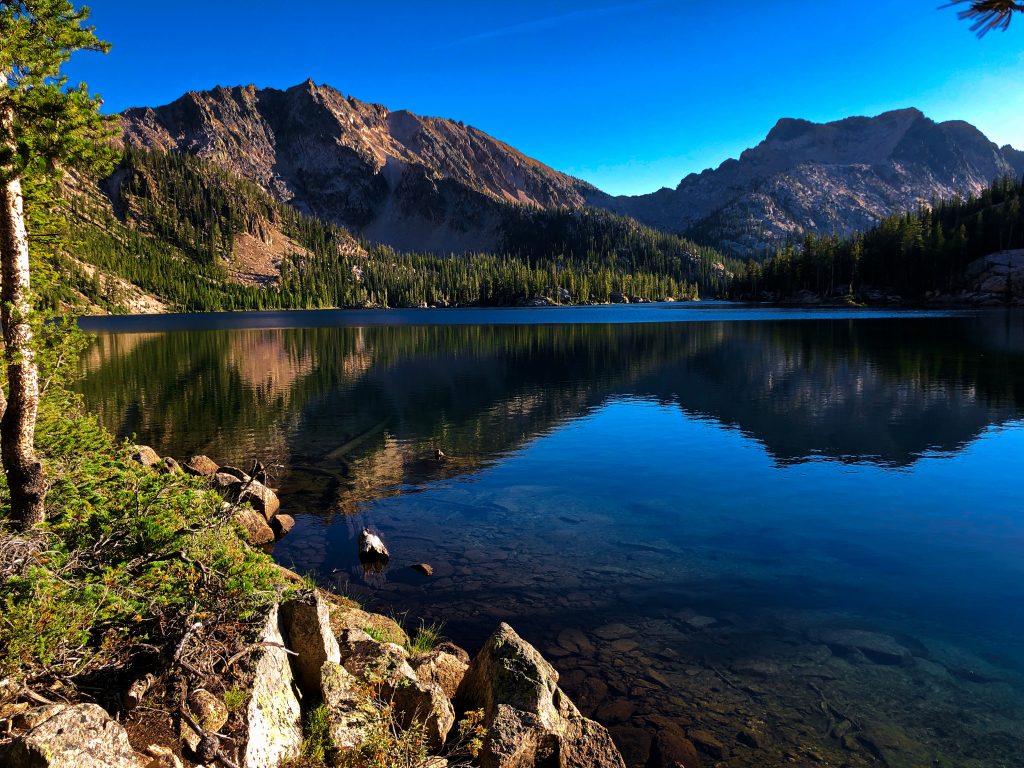

With Imogene Peak and Payette Peak reflecting brilliantly in its clear blue waters, the peaceful beauty of Imogene Lake permeates the soul.

Chris & Mac
We outventure to help you outventure!
For us, outventuring isn’t just about adventure. It’s about the quiet moments — the first light on a ridgeline, the sound of a creek at camp, the shared laughter when the trail gets spicy. We believe the outdoors enriches people’s lives, and we want to help more folks experience that connection. Learn more about us HERE.
Scroll down for full slideshow.
Length: 18 Miles Round Trip
Trailhead(s): Hell Roaring Creek Lower Trailhead *
Elevation Gain: 1,714’
Trail Type: Out & Back
Dogs: Allowed
Difficulty: Easy to Moderate
Permit Required? Yes – Wilderness Permit Self Issue at trailhead (Free)
Considerations: Lingering Snow; Early Snow
Season: Summer – Early Fall (Best)
* From Idaho 75 head west on US Forest Road 209 to US Forest Service Road 315. Follow US Forest Service Road 315 south to Lower Hellroaring Creek Trailhead (see map below Overview)
Overview
With Imogene Peak and Payette Peak reflecting brilliantly in its clear blue waters, the peaceful beauty of Imogene Lake permeates the soul.
BACKPACK TO IMOGENE LAKE
The 18 mile round trip to Imogene Lake from the Lower Hell Roaring Creek Trailhead is beyond what most of us can or want to do. Departing from the upper trailhead (a very rough and bumpy road to get there) saves about 4.5 miles round trip, but a 13+ mile day is still a long hike which leaves little time to enjoy the scenery. As such, those who seek an immersive experience in the magnificent splendor of the Sawtooth Wilderness spend a couple of days backpacking instead. Trust us. This special place deserves more time to fully appreciate not just the journey, but also beautiful Hell Roaring Lake and dreamy Imogene Lake.
Lower Hell Roaring Creek Trailhead to Hell Roaring Lake
There are a couple of benefits to traveling to Imogene Lake via the Hell Roaring Trail. One, it is the quickest and easiest route. Two, it routes us past beautiful Hell Roaring Lake.
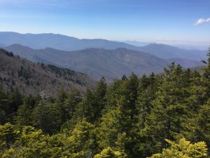
Departing the Lower Hell Roaring Creek Trailhead, the quiet peace of the forest and the gentle babble of the creek accompany backpackers on the way to Hell Roaring Lake. The trail only climbs about 700 feet over five miles to Hell Roaring Lake, with about 300 feet of it coming in the first three quarters of a mile. Afterwards the trail ascends gently with on and off views of lovely Hell Roaring Creek. Otherwise, backpackers are completely engulfed by the beautiful trees and the quiet of the surrounding forest. Things change, however, upon reaching Hell Roaring Lake.
Hell Roaring Lake
The Hell Roaring Trail terminates at the east side of Hell Roaring Lake where it meets the Alice Lake-Hell Roaring Lake Trail coming from Redfish Lake. This trail leads to Imogene Lake, and continues another 8+ miles past Imogene Lake to where it terminates at Snowyside Pass.
Crossing the log footbridge spanning the creek just past the marked junction are full on views of the craggy peaks lying beyond the lake. There are lovely views along this half mile stretch of trail as it skirts the eastern shore of the lake. As we hiked by, we admired the pretty blue and aqua waters of the lake beneath the rolling hillsides on the opposite shore with white peaks perched atop them. The distinctive one that looks like a finger pointing skyward is called the Finger of Fate.
Camping at Hell Roaring Lake
There are several campsites slightly above the trail. Backpackers camping along here can expect to greet everyone who comes by. There was little to no privacy. At the far end of the lake before the trail starts climbing, however, we heard backpackers below the trail in the trees. If we were to camp here, we would venture down to see if we could snag a more private campsite in this area.
Hell Roaring Lake to Imogene Lake
After Hell Roaring Lake the trail gets a bit more serious about climbing up to Imogene Lake. Although there are a couple of steeper stretches, it is not a strenuous ascent between the two lakes. The trail climbs another thousand feet over about four miles. Above Hell Roaring Lake the trees open up in a few places for views looking back and down on the lake. They do not cause us to stop, but we do slow our pace to check them out as we climb into an increasingly rocky landscape. The trail, however, remains fairly non-technical.
Imogene Lake
Upon reaching the outskirts of Imogene Lake we came upon a footpath which led to a marshy drainage from the lake. Carefully picking our way through brought us a to gorgeous campsite. It was perfectly situated behind a large rock outcropping at a small cove on the north side of the lake. Other than backpackers who had set up further out along the western shore of the lake no one else was here as far as we could see.
The small cove with its crystal clear aqua blue water was absolutely beautiful. Setting ourselves in the sun next to it, we spent the afternoon lazily soaking in views of Imogene Peak and Payette Peak. We were not surprised to see squirrels and chipmunks come near as soon as food appeared. The same was not true of our dog, Geo.
She had been dozing in the sun, resting from her trek up to the lake. Once she caught wind of the little brown and tan bodies scurrying around the rocks, however, it was GAME ON! They had her full attention, and we got to enjoy an entertaining episode of “dog chase chipmunk, dog chase squirrel.” It was amusing, and not only did her vigilance keep these little ones from bothering us, it kept all of us highly entertained. Win-win!
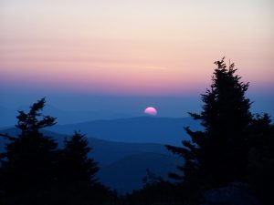
Weather Matters – Where’s the Sun?
Our backpack to Imogene Lake took place on August 30 and August 31. We had lovely bright blue skies and sunshine for our hike in. It was chilly, but not bad because we were moving. When we stopped, however, the coolness of the air was apparent. Fortunately our campsite had plenty of sunshine to keep us warm that afternoon. In colder weather we search for campsites like this that have sunshine on them long into the day. A fact of mountain backpacking is that once the sun settles behind a mountain peak it can get bitterly cold.
Weather Matters – Cold Nights & Fickle Skies
This is exactly what happened at Imogene Lake. When the sun set it was no longer chilly – it was cold. Donning our warm gear layers (long underwear, down jackets, hats, and gloves) we prepared dinner before it got colder. By the time we were done eating and had cleaned and packed up it was too frigid to stay out any longer.
Taking refuge in our sleeping bags we enjoyed a long rest that night, and were up early the next morning. Geo is a fantastic bag warmer and I was glad to have her company. By the time we got up the next morning it was freezing cold. Since she only had her fleece for warmth, I wrapped Geo in my warm sleeping shirt and put my fleece buff around her neck to help keep her warm while we packed up.
Just after I got my tent rolled up it started snowing. The cold was expected, however this was not. The forecast the day before had zero mention of precipitation, let alone snow. Without skipping a beat we put on our rain gear to keep dry, finished packing up, and hit the trail. Happily, we all warmed quickly as we hiked down, and the snow stopped falling before we reached Hell Roaring Lake. Backpackers we spoke to there reported snow as well.
The message is very simple. Be prepared for the gamut of what the Sawtooths can throw at you. The weather here can be brutal, it gets cold at night, and things can change quickly and unpredictably.
Scroll down to learn about the GEAR WE USE and OTHER OUTVENTURES in this area.
Additional Information (Click below to follow links.)
Backpack to Imogene Lake Slideshow
(Click image to expand.)
Gear We Use for Backpacking
To see descriptions of the gear Chris & Mac use for backpacking, as well as links to manufacturers and retailers offering the gear for sale, please CLICK HERE.

Articles About Other Regional Outventures
SAFETY DISCLAIMER: The activities discussed in this website are outdoor activities and, as such, have inherent risks to which participants are exposed. It is not the intent of this website, nor is it possible due to the variability of weather, terrain, equipment, and experience, to detail all of those risks. The information contained in this site is informational, but not instructive nor exhaustive. It is the sole responsibility of the user to ensure he/she is in good health, fully prepared, and fully informed as to dangers before undertaking any of the activities discussed in this website and the user does so at his/her own risk. The user understands that by using this website he/she acknowledges and accepts all risks associated with use of information from this website and participation in any particular activity addressed herein. Please see “Terms of Use” for additional information.
Want to share this article with your friends? Click on the share button below:
Want more?
Get the latest outventure updates by following us on social media . . .