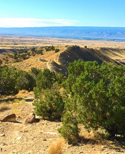
North of Ketchum in Idaho is a small mountain biking trail system, but it packs some great riding and offers something for all skill levels.

Chris & Mac
We outventure to help you outventure!
For us, outventuring isn’t just about adventure. It’s about the quiet moments — the first light on a ridgeline, the sound of a creek at camp, the shared laughter when the trail gets spicy. We believe the outdoors enriches people’s lives, and we want to help more folks experience that connection. Learn more about us HERE.
Scroll down for full slideshow.
Length: 6 Trails with 19 Miles of Trail in the System
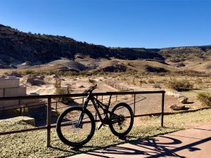
Trailhead(s): Wood River Trail Trailhead
Elevation Gain: 4,875’
Trail Type: Trail System
Dogs: Allowed
Difficulty: Beginner to Advanced
Permit Required? No
Considerations: Popular area for hiking as well as mountain biking; a lot of trail usage; must park at trailhead, then ride through neighborhood for start of trail.
Season: Spring to Fall
Overview
North of Ketchum is a relatively small mountain biking trail system, but it packs some great riding. Located, well, north of Ketchum, Idaho, this trail system offers something to all levels of mountain bikers.
What Makes the North of Ketchum Mountain Biking Trails so Fun?
That’s easy – buff, flowy trails with opportunities for easy spins, moderate climbing and fast descents, or hefty climbing and rugged descents. Wrapped around all this fun is also some awesome views. As an added bonus, the variety of trail conditions at North of Ketchum makes this an excellent choice for groups that have varying skill levels.
Riding the North of Ketchum Mountain Biking Trails
Although there are a couple of ways to access the trail system, the main way is to park at the Wood River Trail Trailhead or proceed just past it on West Sage Road to another parking area down the road, then ride through the neighborhood to an entry gate on Hulen Road. The ride isn’t far and accessing the system here allows a great warm-up for the upper elevations of the system.
A very popular, but short ride, is to take Fox Creek (Lower) to the Fox Creek Loop and back to the trailhead for a 6.1 mile ride with 731′ of climbing. The riding is easy and flowy, and this route is great for beginners.
If you want to up the ante further, instead of going left to continue the Fox Creek Loop, continue straight on to the North Fork Trail to Chocolate Gulch and follow it around back to the Fox Creek Loop then to Fox Creek (Lower). This ride gives some great climbing, nice flow, excellent views, and a ripping downhill from the top of Chocolate Gulch to the Fox Creek Loop, followed by a little climbing and a 3.9 mile downhill back to the entry gate. This is a solid intermediate ride of 12.4 total miles with 1,976′ of climbing and 1,976′ of descent. It’s a ton of fun for both intermediate and advanced riders.
If you want to up the game even further, a popular advanced ride is to pick up the lower Oregon Gulch and Oregon Fox Connector. Because this is about a 21 mile ride with substantial climbing if you start at the entry gate, most people start the ride at a parking area near the intersection of the Fox Creek Loop and the North Fork Loop. (The road leading to this parking area is dirt and unnamed, so use these GPS coordinates: 43.75809645030898, -114.39695774943286.
From the unnamed parking area, get on Fox Creek Loop, then take an immediate right on to the North Fork Loop. Stay straight when North Fork intersects Chocolate Gulch and take this to the Saddle Trail. When you reach lower Oregon Gulch, take a left and ride to a left on the Oregon-Fox Connector. On this advanced trail, expect hefty climbs, a number of hike-a-bikes, a ripping downhill, and some solid chunk. When you get to the bottom, take a left on the Fox Creek Loop and follow it back to where you started. This baby is going to give you 12.4 miles of riding with 2,625′ of climbing and descent. Oh, and a big smile!
Final Thoughts about the North of Ketchum Mountain Biking Trail System
There are, of course, numerous other routes you can put together at North of Ketchum. (Heck, if you want to, you can even connect to another great system – Adams Gulch!) Above I shared with you what I believe to be great loops for beginners, intermediates, and advanced riders to get you started, but go explore the system. You’ll have a blast!
Scroll down to learn about the GEAR WE USE and OTHER OUTVENTURES in this area.
Additional Information (Click below to follow links.)
North of Ketchum Slideshow
(Click image to expand.)
Trailforks Interactive Trail Map:
Gear We Use for Mountain Biking
To see descriptions of the gear Chris & Mac use for mountain biking, as well as links to manufacturers and retailers offering the gear for sale, please CLICK HERE.

Articles About Other Regional Outventures
SAFETY DISCLAIMER: The activities discussed in this website are outdoor activities and, as such, have inherent risks to which participants are exposed. It is not the intent of this website, nor is it possible due to the variability of weather, terrain, equipment, and experience, to detail all of those risks. The information contained in this site is informational, but not instructive nor exhaustive. It is the sole responsibility of the user to ensure he/she is in good health, fully prepared, and fully informed as to dangers before undertaking any of the activities discussed in this website and the user does so at his/her own risk. The user understands that by using this website he/she acknowledges and accepts all risks associated with use of information from this website and participation in any particular activity addressed herein. Please see “Terms of Use” for additional information.
Want to share this article with your friends? Click on the share button below:
Want more?
Get the latest outventure updates by following us on social media . . .