The Flume Trail is an incredibly beautiful mountain bike ride high above Lake Tahoe that should be on every mountain biker’s bucket list.

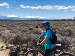
Chris & Mac
We outventure to help you outventure!
For us, outventuring isn’t just about adventure. It’s about the quiet moments — the first light on a ridgeline, the sound of a creek at camp, the shared laughter when the trail gets spicy. We believe the outdoors enriches people’s lives, and we want to help more folks experience that connection. Learn more about us HERE.
Scroll down for full slideshow.
Length: 13.2 Miles – As Ridden, See Considerations
Trailhead(s): Spooner Lake State Park
Elevation Gain: 2,206’ (2,940′ Descent) – As Ridden, See Considerations
Trail Type: Point to Point
Dogs: No
Difficulty: Moderate
Permit Required? No
Considerations: Usually shuttled; Article shows most popular route, but there is an IMBA Epic route of 24 miles beginning at Tahoe Meadows Tahoe Rim Trail Trailhead; Trailforks interactive map (below) shows full Epic ride, see slideshow after write-up for a map of the popular route covered in this article.
Season: Late Spring, Summer, Fall
Overview
The Flume Trail is an incredibly beautiful mountain bike ride on gorgeous trail high above Lake Tahoe. This ride should be on every mountain biker’s bucket list – no fooling, I’ve ridden all over the country and the Flume Trail blew me away!
Why is the Flume Trail Mountain Bike Ride so Incredible?
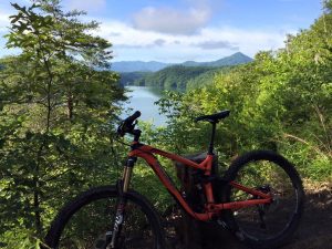
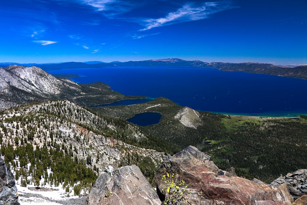
First and foremost, the scenery is gorgeous, as the slideshow below demonstrates. You will be riding about 1,800′ above the edge of Lake Tahoe with incredible views of the lake ringed by mountains on the opposite shore. The water is a deep royal blue, the mountains are snow capped, and the trail has beautiful white stone and sand lined with green pine trees and manzanita. If that doesn’t fill your soul, I’m not sure what will.
In addition to the views, the riding is buff. This is not a technical ride. In fact, the Marlette Flume Trail portion of the ride is marked as beginner on Trailforks, although the exposure on the trail will make you want to challenge that rating. This ride does not need to be technical, however, because it is about experiencing the natural beauty of Lake Tahoe. Due to this beauty and the Flume’s flowy trail, this ride has actually been voted as one of the top ten mountain bike rides in the United States.
Finally, if incredible views and flowy trail don’t do it for you, the ride is just a great spin. You’ll cover 13.2 miles with 2,206′ of climbing and a descent of 2,940′. This will give even hard core riders a good workout and a fun day of riding.
Spinning the Flume Trail Mountain Bike Ride
As noted in “Considerations” above, this article is about the most popular way to ride the Flume Trail. There is an alternative, which IMBA (International Mountain Biking Association) designated as an Epic trail ride, but that route will be covered in another article. The ride discussed herein is the one most people who want to experience the Flume Trail will choose.
It is possible to do the Flume Trail ride as an out & back, but most people choose to do the ride as a shuttle. You can either handle the shuttle yourself using 2 cars or use a shuttle service to take you to the start, then ride back to your car. (We used Flume Trail Bikes in Incline Village and thought the service was excellent.)
Regardless of whether you shuttle yourselves or use a shuttle service, the ride described here starts at where most riders start, Spooner Lake State Park. When you enter the park your shuttle driver or the entrance ranger will point you to the start. From here you begin your climb from 7,000′ to 8,157′ before beginning your (mostly) descent.
Be forewarned, during the first 4 miles, you will climb a little over 1,100′. The steepest part of the climb occurs during the last .5 miles and quite a few people walk this portion. The overall climb is not terrible and it is on non-technical double track, but if you are not in climbing shape, realize that you will want to take your time with the climb.
Once you top out at 8,157′ at the Marlette Saddle, take a break under the gorgeous lodgepole pines at the top. The setting is very pretty and you’ve earned a break. This is a mountain bike ride you will want to savor, so don’t rush.
After your break, take the short descent to the pretty Marlette Lake. From here, you will ride 1.5 miles on a dirt road to the Marlette Reservoir where the Marlette Flume Trail (the main attraction) begins. The road you are riding will run directly into the Marlette Flume Trail, which is well marked and hard to miss.
The ride to this point is pretty and fun, but get ready to be blown away. The Marlette Flume Trail runs along the mountain side as much as 1,800′ above the Lake Tahoe shore and as close as .5 miles from the shore’s edge. There is definitely exposure and if you want to take in the views, it is recommended you stop to avoid a quick “descent” to the shore below.
The Marlette Flume Trail is, in total, a descent with short ups and downs along the way. This is the most scenic part of the ride and it is jaw droppingly beautiful. Take your time and really enjoy this trail. Be aware, too, the trail is two-way and hikers are allowed on the trail, so be patient and courteous.
At the end of the Marlette Flume Trail, stay straight to go on Tunnel Creek Road. From here, it is a 3 mile, 1,500′ descent on double track back to your car at Incline Village. This is a fun, ripping descent, but be aware that it is very sandy in some places and some of the turns are primed for slide-outs.
When you get back to your car, bask in the satisfaction of this amazing ride. If you weren’t totally blown away by the scenery on your Flume Trail ride, I will be amazed.
Final Thoughts about the Flume Trail Mountain Bike Ride
The Flume Trail is a truly amazing mountain bike ride. Much of mountain biking is about fun, flow, and challenge, but often without views, much less incredible views. This one definitely gives you the fun, the flow, and some challenge, but the views are the show stopper. I hope you enjoy riding this as much as I did. OUTventure on!
Scroll down to learn about the GEAR WE USE and OTHER OUTVENTURES in this area.
Additional Information (Click below to follow links.)
The Flume Trail Slideshow
(Click image to expand.)
Trailforks Interactive Trail Map:
Gear We Use for Mountain Biking
To see descriptions of the gear Chris & Mac use for mountain biking, as well as links to manufacturers and retailers offering the gear for sale, please CLICK HERE.
Articles About Other Regional Outventures
SAFETY DISCLAIMER: The activities discussed in this website are outdoor activities and, as such, have inherent risks to which participants are exposed. It is not the intent of this website, nor is it possible due to the variability of weather, terrain, equipment, and experience, to detail all of those risks. The information contained in this site is informational, but not instructive nor exhaustive. It is the sole responsibility of the user to ensure he/she is in good health, fully prepared, and fully informed as to dangers before undertaking any of the activities discussed in this website and the user does so at his/her own risk. The user understands that by using this website he/she acknowledges and accepts all risks associated with use of information from this website and participation in any particular activity addressed herein. Please see “Terms of Use” for additional information.
Want to share this article with your friends? Click on the share button below:
Want more?
Get the latest outventure updates by following us on social media . . .