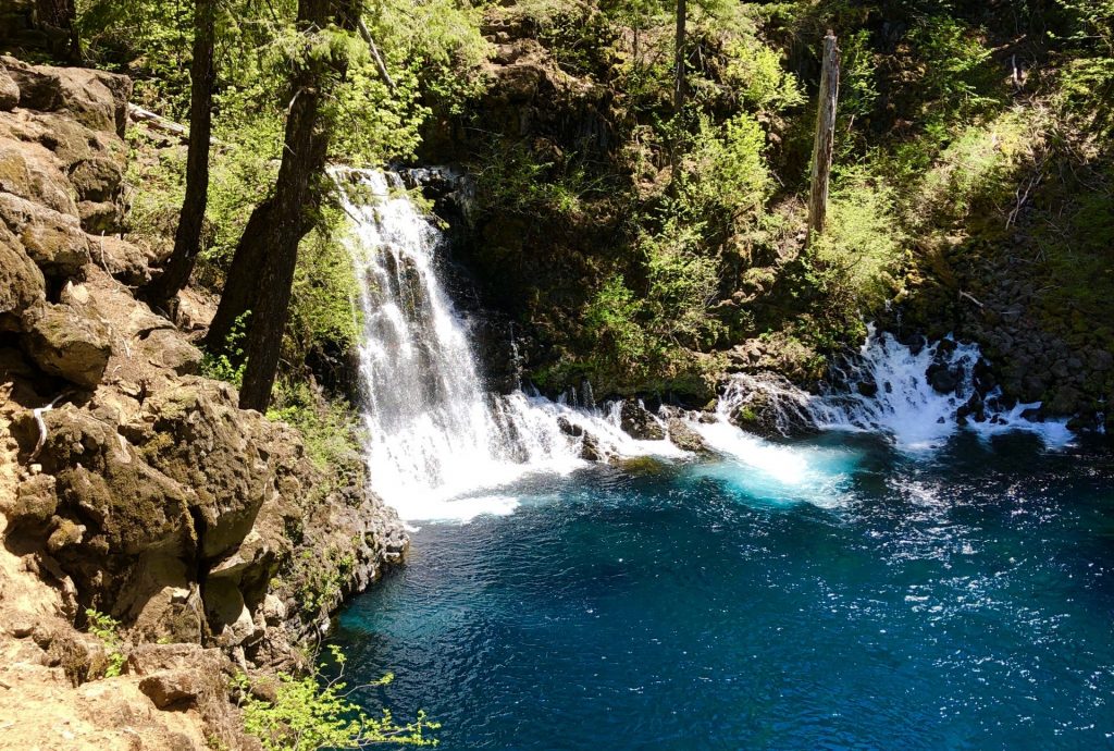
Oregon’s McKenzie River Trail is an outstanding mountain bike ride through beautiful forest along a cobalt blue river.
Chris & Mac
We outventure to help you outventure!
Support Grey Otter Outventures!
Please help us continue to bring you great content:
Scroll down for full slideshow.
Length: 25.7 Miles
Trailhead(s): McKenzie River Trailhead (Upper)
Elevation Gain: 1,510’ (3,225′ Descent)
Trail Type: Point to Point
Dogs: Allowed
Difficulty: Advanced
Permit Required? No
Considerations: Requires shuttle.
Season: Spring through Fall
Oregon’s McKenzie River Trail is an outstanding mountain bike ride through beautiful forest along a cobalt blue river. Depending on chosen route and trail conditions, it can be a beast, but you’ll be glad you rode the trail that Bike Magazine readers chose as the best mountain bike trail in America!
What Makes the McKenzie River Trail such an Amazing Mountain Bike Ride?
A lot. Let’s start with the fact that the trail travels through beautiful old growth forest on the western slopes of Oregon’s Cascade range. Add to it that the McKenzie River has beautiful cobalt blue waters, a gorgeous lake called “Clear Lake”, numerous scenic waterfalls, and the stellar Tamolitch pool (the Blue Pool).
Then, there is the riding. The mostly loam trail has plenty of climbs and descents, a lot of rock and some pretty technical sections, and plenty of opportunity for speed as well as cross country spinning. What’s not to love?
Mountain Biking the McKenzie River Trail
At 25.7 miles, the McKenzie River Trail is a long mountain bike ride for most people, but the technical sections, the crowds of people around the Tamolitch pool, mud (it’s often wet), and numerous stops to enjoy beautiful views of the river and waterfalls makes the ride seem much longer. Don’t get me wrong, you’ll want to savor every inch of this ride – it’s that good.
Due to the length of the trail, all but the superhuman will want to shuttle this ride. There are 11 trailheads along the McKenzie River trail, so it is not necessary to ride the whole trail. If you want to ride the entire 25.7 miles, however, park a car at the final parking area (GPS coordinates: 44.17668, -1221381), then begin your ride from the upper McKenzie River Trailhead marked on the map below. Beginning at this trailhead, you will ride across a bridge and you’re on your way. You’ll have some climbing over the next 25.7 miles, but an overall descent of 3,225′ is the gift for your efforts.
As for the trail’s difficulty, Trailforks has the trail rated as advanced. I think this is a reasonable rating overall (particularly if you don’t take the Clear Lake option I will discuss in a moment) due to the distance, physical demands of the trail, and some of the technical rock features. Sections of the trail, however, fall solidly into the intermediate range, so I think it beneficial to address the trail by sections.
The first 10-11 miles are definitely advanced. There is a lot of lava rock and some technical climbing, but the views through this stretch are outstanding. This stretch is also where you will encounter the toughest technical section on the McKenzie River Trail.
Shortly after beginning the trail at the upper trailhead, you will reach a decision point just before you reach Clear Lake. You will hit a junction where you can continue on the McKenzie River Trail or take the Clear Lake Trail.
If you continue the McKenzie River Trail at the junction, you will enter a lava flow field that hugs the entire western shoreline of beautiful Clear Lake. This lava field is no joke. If you love technical riding, you’ll have a ball. Be warned, however, the field is all rock with punchy ups and downs, many turns, and no way to carry momentum. Navigating the field is mostly through brute force. Also be aware that lava rock is sharp, so you will get cut if you brush the rocks and worse so if you fall. If you’re up for all that, it is really a blast to ride.
If you don’t want to test your skills in the lava flow field, you can take the Clear Lake Trail to the right at the junction. This intermediate trail follows the eastern side of Clear Lake with great views of the lake and allows you to avoid the demands of the McKenzie River Trail on the other side of the lake.
During first 10-11 miles, you will also encounter the best waterfalls on the McKenzie River and the incredibly beautiful Tamolitch pool. Take your time and enjoy these sites. It’s not that the rest of the ride isn’t beautiful, it is, but the best of the best is in this stretch. Of note, when you get near Tamolitch, you will encounter a lot of people who hike to the cobalt blue pool. Please be courteous so we can keep this trail open to mountain biking.
Continuing on, miles 11-13 are a pretty good spin. You will still encounter a good amount of rock, but you will also encounter some great flow.
The last 12 miles of the trail really fall solidly into the intermediate range. The trail through here has good tread and excellent flow. There are some occasional technical sections and some bigger climbs, but all of it is completely manageable and just plain fun riding. The views are also outstanding. As with the rest of the trail, you will encounter a number of handmade bridges which you should carry your bike across to avoid joining the swim team.
The McKenzie River Trail ends by popping you out of the forest next to a roadside parking area (GPS coordinates: 44.17668, -1221381). This is where you will want to have left your car or have you friends pick you up. Be warned, the parking area does get busy. Many people park here to hike or mountain bike the lower part of the McKenzie River Trail, in addition to those who ride the entire trail.
Concluding Thoughts about the McKenzie River Trail
The McKenzie River Trail really is a top notch mountain bike ride. I’ve ridden all over the country, as well as British Columbia, and I have not encountered anything quite like the mix of terrain and beauty this trail offers. I think there are better trails, but this one should be on every mountain biker’s bucket list. If you are anywhere near central Oregon, make sure to add this to your mountain biking itinerary. Enjoy!
Scroll down to learn about the GEAR WE USE and OTHER OUTVENTURES in this area.
Additional Information (Click below to follow links.)
McKenzie River Trail Slideshow
(Click image to expand.)
Trailforks Interactive Trail Map:
Gear We Use for Mountain Biking
To see descriptions of the gear Chris & Mac use for mountain biking, as well as links to manufacturers and retailers offering the gear for sale, please CLICK HERE.

Articles About Other Regional Outventures
SAFETY DISCLAIMER: The activities discussed in this website are outdoor activities and, as such, have inherent risks to which participants are exposed. It is not the intent of this website, nor is it possible due to the variability of weather, terrain, equipment, and experience, to detail all of those risks. The information contained in this site is informational, but not instructive nor exhaustive. It is the sole responsibility of the user to ensure he/she is in good health, fully prepared, and fully informed as to dangers before undertaking any of the activities discussed in this website and the user does so at his/her own risk. The user understands that by using this website he/she acknowledges and accepts all risks associated with use of information from this website and participation in any particular activity addressed herein. Please see “Terms of Use” for additional information.
Want to share this article with your friends? Click on the share button below:
Want more?
Get the latest outventure updates by following us on social media . . .


