Man, is Grand Canyon National Park’s North Kaibab Trail leaving from the North Rim different from the South Kaibab Trail that leaves from the South Rim!
Chris & Mac
We outventure to help you outventure!
Support Grey Otter Outventures!
Please help us continue to bring you great content:
Scroll down for full slideshow.
Length: 14 Miles One Way
Trailhead(s): North Kaibab Trailhead, Grand Canyon North Rim
Elevation Gain: -5,761’
Trail Type: Point to Point
Dogs: No
Difficulty: Difficult
Permit Required? Not for Day Hiking
Considerations: Desert Hiking, Extreme Heat Possible, Going Down is Easy/Going Back Up is Hard, Entrance Fee for Grand Canyon is $35, Seasonal Water Sources, Water Lines Subject to Breaks (Check Water Status with Park Before Hiking)
Season: Spring, Summer, Fall
Overview
Man, is Grand Canyon National Park’s North Kaibab Trail leaving from the North Rim different from the South Kaibab Trail that leaves from the South Rim! In large part, this is due to the fact that at an elevation of 8,241′, the North Kaibab trailhead sits almost 1,000′ higher than the South Kaibab trailhead at Yaki Point. This difference in altitude makes for a unique hiking experience in a canyon dominated by rock.
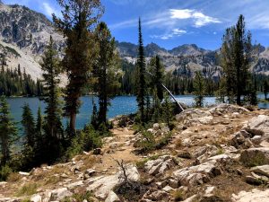
The North Kaibab Trail begins in alpine forest, with limited views of the mostly forested top of Bright Angel Canyon. At this altitude, the trail is dominated by firs, aspens, and ferns. This gives a much different feeling than the red rock terrain of the South Rim of Grand Canyon National Park. As you descend the trail, you will move from the high alpine feel of the North Rim, to the familiar rocky desert that dominates most hikes in the Grand Canyon. Personally, I was really struck by this contrast the first time I saw the North Rim, which sits at the edge of a forested plateau. Having visited the South Rim numerous times to hike and backpack, the North Rim gave me a truly a unique experience in this geologic wonder.
I could go on from here to describe the nuances of the North Kaibab Trail, which is the only trail that leads to the bottom of the Canyon from the North Rim, but the National Park Service produced an outstanding description of the trail in great detail. As such, I will simply refer you to the trail description here. This description will provide you with all the details you need to know about the trail and how to navigate it. For my part, I just want you to know that this is absolutely a trail worth the effort to hike.
Getting to the North Rim is four hour drive from the South Rim. It is, however, only a one hour and forty minute drive from Kanab, UT, which is how we accessed it. The point is that the North Kaibab Trail is not easy to reach. I note this not to discourage you, but to stress that this is a hike worth the effort, even if you have to go out of your way to get there. The trail is gorgeous, it takes you down through numerous ecosystems, and the experience is completely different from the crowded, rocky entrance into the Grand Canyon that you get entering from the South Rim. If you can swing it, I highly recommend you hike this trail!
Scroll down to learn about the GEAR WE USE and OTHER OUTVENTURES in this area.
Additional Information
- Grand Canyon National Park – North Kaibab Trail Description & Information:
https://www.nps.gov/grca/planyourvisit/upload/North_Kaibab_Trail.pdf
- Grand Canyon National Park – North Rim Brochure & Map:
https://www.nps.gov/grca/learn/news/upload/nr-pocket-map.pdf
- Grand Canyon National Park – Day Hiking Guidance & Considerations:
https://www.nps.gov/grca/planyourvisit/day-hiking.htm
North Kaibab Trail Slideshow
(Click image to expand.)
Gear We Use for Day Hiking
To see descriptions of the gear Chris & Mac use for day hiking, as well as links to manufacturers and retailers offering the gear for sale, please CLICK HERE.

Articles About Other Regional Outventures
SAFETY DISCLAIMER: The activities discussed in this website are outdoor activities and, as such, have inherent risks to which participants are exposed. It is not the intent of this website, nor is it possible due to the variability of weather, terrain, equipment, and experience, to detail all of those risks. The information contained in this site is informational, but not instructive nor exhaustive. It is the sole responsibility of the user to ensure he/she is in good health, fully prepared, and fully informed as to dangers before undertaking any of the activities discussed in this website and the user does so at his/her own risk. The user understands that by using this website he/she acknowledges and accepts all risks associated with use of information from this website and participation in any particular activity addressed herein. Please see “Terms of Use” for additional information.
Want to share this article with your friends? Click on the share button below:
Want more?
Get the latest outventure updates by following us on social media . . .


