Length: 10 Miles Round Trip (Approx.)
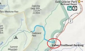
Trailhead(s): Lubec Trailhead, US Hwy 2 Mile Marker 203 (Across Railroad Tracks at False Summit)
Elevation Gain: 2,000’ (Approx.)
Trail Type: Out & Back
Dogs: Not Allowed
Difficulty: Moderate to Strenuous
Permit Required? No
Considerations: Grizzly Bears; Lingering Snow; Bugs
Season: May-October
Overview
Finding wilderness solitude in Glacier National Park can seem like an impossible task, but it is not. Simply travel to the less visited southeastern area of the park and take a hike to Firebrand Pass. Blissful wilderness solitude in Glacier National Park awaits.
Firebrand Pass – Glacier National Park
Owing its name to a hugely destructive wildfire event in 1910 (the year Glacier National Park was established), Firebrand Pass sits in a wide, open saddle between Red Crow Mountain and Calf Robe Mountain. Click here to learn more about the 1910 forest fire event.
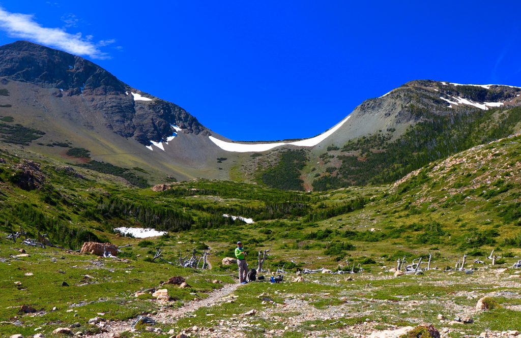
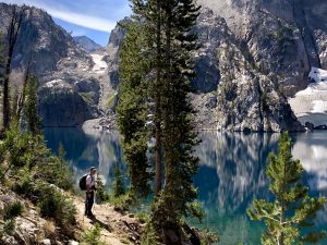
Sitting at an elevation of roughly 6,950 feet, Firebrand Pass is similar to many other mountain passes in that it is a windy place with phenomenal views. Whereas the hike up to Firebrand Pass is captivating and the mountain views are lovely, the final show of this hike is reserved only for those who make the final climb up to the pass. Looking west, the views of Glacier National Park’s massive granite peaks are simply magnificent.
Firebrand Pass Hike
Abundant Beauty
Initially traveling through an expanse of open field before entering beautiful aspen forest, the hike begins with little elevation change and lots of gorgeous. Vibrant wildflowers thickly decorating the open field welcomed us as we began our June hike. With mountain views beyond, the scene was incredibly picturesque. Equally impressive, we found that they blanketed the meadows at higher elevations as well. The amazing array of colors, shapes, and textures that stopped us in our tracks multiple times.
Minor Challenges
Even though the hike to Firebrand Pass is beautiful, it does have some drawbacks. First, although the hike is not overly technical (excepting scree and snow fields below the pass), the trail does at times have more serious elevation changes. Since they are not overly taxing and the grade is manageable, we believe they are at most moderately challenging, particularly those not acclimated to the elevation. Second, the trail is enveloped and thickly lined with tall vegetation (over 5 feet) in some of the old burn areas. It was so overgrown, in fact, that we nearly had to bushwhack our way through. Last but not least of the challenges are hungry mosquitoes which lurk in the forested areas. When we found the mosquitoes (or, rather, they found us) it was an all hands on deck rush for the bug spray.
The Payoff
On the final push around Calf Robe Mountain, however, the vegetation and bugs both thin considerably. The trail becomes much more open, and becomes rock and scree before depositing hikers on a large open bench below the pass. Quite obvious at this point, the pass lies directly ahead. It is clear that the steepest section of trail is yet to come. For those who push on, the final short, steep hike is up a shale/talus slope. At the top of the pass the effort is rewarded with views of some of Glacier National Park’s endless, magnificent snow tipped granite peaks.
Although the trail continues, it does not loop back to the Lubec Trailhead. When done soaking in the sights, turn around to head back down the way you came.
Lubec Trailhead
Park shuttles do not service this area of the park. Because of this, hikers must travel outside the park’s boundaries to get to the Lubec Trailhead. Because it is a bit obscure and has no signage, trailhead parking is a little tricky to find. On our approach from the east we watched for mile marker 203 on Highway 2. We saw it, but passed right by the parking area because we did not observe a definitive trailhead. Finding a safe place to to turn around, we tried again. Successful this time, we found the parking area beside the railroad tracks across from milepost 203. The parking area is a simple gravel drive (parallel parking only) that loops between the highway and the railroad tracks. Once we found it we easily locate the trailhead on the other side of the railroad tracks.
Scroll down to learn about the GEAR WE USE and OTHER OUTVENTURES in this area.
Additional Information (Click below to follow links.)
- National Park Service: Glacier National Park Information Link