The Paulina Lake loop hike has gorgeous views, natural hot springs, wildflowers, and a short side trail leading to a breathtaking waterfall.

Chris & Mac
We outventure to help you outventure!
For us, outventuring isn’t just about adventure. It’s about the quiet moments — the first light on a ridgeline, the sound of a creek at camp, the shared laughter when the trail gets spicy. We believe the outdoors enriches people’s lives, and we want to help more folks experience that connection. Learn more about us HERE.
Scroll down for full slideshow.
Length: 7 miles
Trailhead(s): Paulina Lake Boating Parking Area
Elevation Gain: 218’
Trail Type: Loop
Dogs: Allowed
Difficulty: Easy to Moderate
Permit Required? Yes – $5 Day Use Fee or Valid Recreation Pass*
Considerations: Geothermal Features
Season: Spring-Fall; *Road to Lake Closed at 10 Mile Sno-Park in Winter
* No fee in winter – entrance to monument is past the road closure
Overview
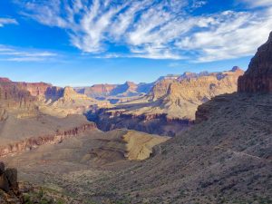
The hiking trail encircling Paulina Lake delivers a peaceful, family friendly adventure – in the caldera of an ancient, but still active volcano. With volcanic rock, gorgeous views, wildflowers, hot springs, and more, this family friendly hike is anything but boring.
PAULINA PEAK, LAKE, CREEK, AND FALLS
Majestically perched atop the 17 square mile caldera of the Newberry Volcano, Paulina Peak overlooks two beautiful caldera lakes – Paulina Lake and East Lake. Sitting in this depression, Paulina Lake is fed entirely by snow melt, natural hot springs, and seepage from East Lake. It outflows into Paulina Creek, a gorgeous ribbon of water that surges down through 5 miles of volcanic rock. A lovely hiking trail follows the creek and passes by numerous waterfalls. The largest of them, Paulina Falls, is easily accessible for viewing while on the Paulina Lake loop hike.
PAULINA LAKE LOOP HIKE
The surface of the trail encircling Paulina Lake alternates between dirt and volcanic rock. Although it routes through rocky terrain, the trail is not difficult which makes it a peaceful hike. Further, it is appealing because beautiful Paulina Lake is almost always visible, and hikers have frequent and easy access to it.
We hike this trail clockwise from the boating parking area. There is not much elevation change, so it is easily hiked in either direction. Heading clockwise hikers soon arrive at a road and bridge that leads to a resort on the lake. The trail continues by the parking area up to the left (often closed off) at the far end of the bridge. We like to deviate from the trail here to see Paulina Falls.
Paulina Falls
Instead of crossing the bridge, cross the road and get on the Paulina Creek Falls Trail. This is 100% a detour worth taking. It is only a short stroll to the Paulina Falls overlook. A spur trail past the overlook leads down to the creek for those wanting to view this waterfall from below. When done admiring this beautiful waterfall follow the trail back to the road to continue the Paulina Lake loop hike.
VOLCANIC FEATURES
On the northern and north eastern shore of Paulina Lake lie two areas of special interest to hikers: natural hot springs and an obsidian field.
Natural Hot Springs
The natural hot springs which feed Paulina Lake bubble up through the pebbles along Paulina Lake’s northern shore. A marked spur trail approximately 3 miles from the trailhead leads down to the waters edge and the hot springs. Because they are ringed with logs their location is easy to identify. Thankfully lacking the heavy sulfur smell which often emanates from this type of geothermal feature, the peaceful shoreline here has plenty of room so visitors can spread out and enjoy them.
In between the hot springs and the Little Crater Campground (1.2 miles further along the trail) hikers walk through a gorgeous obsidian glass flow field.
Obsidian Glass
Obsidian glass forms when a particular type of lava flow cools quickly without much crystal growth. To learn more about obsidian CLICK HERE. This is why obsidian glass exists at the Newberry Volcano. For those wanting to see it, a huge obsidian flow is deposited on the hills above Paulina Lake. Visitors can explore it, but that short hiking trail is not connected to the Paulina Lake loop trail. Fortunately, it is not the only place to see obsidian here.
The Paulina Lake loop hike includes an area littered with an abundance of black obsidian glass. Whereas the trail is otherwise strewn with volcanic basalt rock, the only place along the trail with these beautiful black rocks is on the northeastern side of Paulina Lake. On a sunny day they glisten brilliantly. Take pictures and leave it where you find it because it is illegal to remove obsidian from this trail.
VISITING IN THE WINTER
We would be remiss if we did not tell you that the entire area surrounding Paulina Peak is simply gorgeous in the winter when everything is covered in white. Unfortunately, ten miles in from Highway 97 the road leading up to Paulina Lake is closed (locked gate) in the winter. Although it remains closed until the heavy snow pack has melted, fortunately the lake and waterfall are accessible because the area is a winter wonder playland people flock to.
10 Mile Sno-Park Trailhead
Park at the 10 Mile sno-park (sno-park pass required) which is located where the road closes. From here a 3 mile trail through the forest leads up to Paulina Falls. It is stunningly beautiful in the winter. Some ski this trail, but we prefer to snowshoe it. On ski’s we take either the closed road or an alternate trail that starts near the warming shelter, crosses the road, and runs to the south/west of the closed road. The road is shared with snowmobiles, but since they have their own forest trails to play on their use of the road is not heavy. We like the road route because of the overlook we encounter on the way up. On a clear day it has great long distance views.
Scroll down to learn about the GEAR WE USE and OTHER OUTVENTURES in this area.
Additional Information (Click below to follow links.)
Paulina Lake Loop Slideshow
(Click image to expand.)
Gear We Use for Day Hiking
To see descriptions of the gear Chris & Mac use for day hiking, as well as links to manufacturers and retailers offering the gear for sale, please CLICK HERE.

Articles About Other Regional Outventures
SAFETY DISCLAIMER: The activities discussed in this website are outdoor activities and, as such, have inherent risks to which participants are exposed. It is not the intent of this website, nor is it possible due to the variability of weather, terrain, equipment, and experience, to detail all of those risks. The information contained in this site is informational, but not instructive nor exhaustive. It is the sole responsibility of the user to ensure he/she is in good health, fully prepared, and fully informed as to dangers before undertaking any of the activities discussed in this website and the user does so at his/her own risk. The user understands that by using this website he/she acknowledges and accepts all risks associated with use of information from this website and participation in any particular activity addressed herein. Please see “Terms of Use” for additional information.
Want to share this article with your friends? Click on the share button below:
Want more?
Get the latest outventure updates by following us on social media . . .