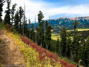
Boy, are Croy Creek mountain biking trails fun riding! You won’t find anything gnarly, but if you’re looking for sweet riding, look here.

Chris & Mac
We outventure to help you outventure!
For us, outventuring isn’t just about adventure. It’s about the quiet moments — the first light on a ridgeline, the sound of a creek at camp, the shared laughter when the trail gets spicy. We believe the outdoors enriches people’s lives, and we want to help more folks experience that connection. Learn more about us HERE.
Scroll down for full slideshow.
Length: 10 Trails, 37 Miles of Trail
Trailhead(s): Croy Creek/BMX Track Trailhead
Elevation Gain: Dependent on Chosen Route
Trail Type: Trail System
Dogs: Allowed
Difficulty: Beginner to Intermediate
Permit Required? No
Considerations:
Season: Late Spring, Summer, Early Fall
Overview
Boy, are Croy Creek mountain biking trails fun riding! You won’t find anything hectic, but if you’re looking for sweet riding, look here. The trail system is just minutes away from Sun Valley and the awesome riding of Ketchum, Idaho. It’s not a big system, but it will give you a big smile.
What Makes the Croy Creek Mountain Biking Trails so Fun?
Buff singletrack! The Ketchum, Idaho area is blessed with volcanic ash that blankets the ground’s surface throughout the area. Over time, the ash became a stable dirt base that makes for perfect riding. There are, of course, rocks on the trail, but for the most part the Croy Creek mountain biking trails are as smooth as a baby’s bottom.
In addition to buff singletrack, this is a new trail system where current trail building technologies were clearly used to create expertly built and routed trails. This expertise created trails which are never too steep to enjoy climbing and a ton of fun to descend. No, adrenalin junkies are not going to get the juice of a burley set of technical trails, but, at least for me, it is not always about the adrenalin. Great singletrack riding, itself, brings an abundance of fun and satisfaction.
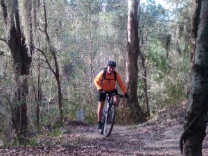
Riding the Croy Creek Mountain Biking Trails
The Croy Creek trails system has 1 double track, 1 beginner, and 8 intermediate trails. The beginner trail is only one-tenth of a mile and the double track is, well, double track. Neither is worth further mention. Our focus is the 8 intermediate trails covering roughly 18 miles.
Among the intermediate trails, a particularly fun ride is Bullion Connector to the Hidden Valley loop. Connecting the two creates a popsicle stick ride of 11.9 miles with a gain/descent of 2,180′. There is a climb on Bullion to get to Hidden Valley, but you are rewarded on the return with a great downhill.
When you get to Hidden Valley, for maximum fun you should ride the loop counter-clockwise. You will get some short downhills and climbs to start, but you then hit a long, ripping downhill with some rock and scree to keep it interesting before you get back to Bullion for your downhill return to the trailhead.
The other side of the Croy Creek system is also a blast. A fun loop on that side follows BMX Flow to Two Dog to Bull Dog, then a left on Bullion Gulch Road for just a short distance, picking up Bullion Connector for the downhill back to BMX Flow and the trailhead. It’s a fun, fast ride with reasonable climbs and great downhills. All tolled, you’ll cover 11.5 miles and climb/descend 1,952′, smiling the whole way.
There are, of course, other routes you can choose. These are just a couple of suggestions, so don’t be afraid to explore at will and find your own great riding.
Final Thoughts about the Croy Creek Mountain Biking Trail System
Croy Creek is an excellent trail system for intermediate riders and a great place for beginners to work on building their skills. But advanced riders, don’t miss out. Croy Creek’s mountain biking trails have that perfect flow which allows you to ride hard, fast, and have a ton of fun too! This small, new system is really a blast to ride and, when you combine it with all the mountain biking Ketchum and Sun Valley area has to offer, it is a great enhancement to a week (or more!) of riding. Have fun!
Scroll down to learn about the GEAR WE USE and OTHER OUTVENTURES in this area.
Additional Information (Click below to follow links.)
Croy Creek Mountain Biking Trails Slideshow
(Click image to expand.)
Trailforks Interactive Trail Map:
Gear We Use for Mountain Biking
To see descriptions of the gear Chris & Mac use for mountain biking, as well as links to manufacturers and retailers offering the gear for sale, please CLICK HERE.

Articles About Other Regional Outventures
SAFETY DISCLAIMER: The activities discussed in this website are outdoor activities and, as such, have inherent risks to which participants are exposed. It is not the intent of this website, nor is it possible due to the variability of weather, terrain, equipment, and experience, to detail all of those risks. The information contained in this site is informational, but not instructive nor exhaustive. It is the sole responsibility of the user to ensure he/she is in good health, fully prepared, and fully informed as to dangers before undertaking any of the activities discussed in this website and the user does so at his/her own risk. The user understands that by using this website he/she acknowledges and accepts all risks associated with use of information from this website and participation in any particular activity addressed herein. Please see “Terms of Use” for additional information.
Want to share this article with your friends? Click on the share button below:
Want more?
Get the latest outventure updates by following us on social media . . .