Idaho’s White Clouds Loop is a spectacularly beautiful and adventurous trip for those with advanced backpacking and navigation skills.

Chris & Mac
We outventure to help you outventure!
For us, outventuring isn’t just about adventure. It’s about the quiet moments — the first light on a ridgeline, the sound of a creek at camp, the shared laughter when the trail gets spicy. We believe the outdoors enriches people’s lives, and we want to help more folks experience that connection. Learn more about us HERE.
Scroll down for full slideshow.
Length: 27.14 Miles
Trailhead(s): Fourth of July Trailhead
Elevation Gain: 6,435’
Trail Type: Loop
Dogs: Allowed, but Not Advised Due to Off Trail Demands
Difficulty: Advanced
Permit Required? No
Considerations: Advanced hiking and navigation skills required; 7.5 miles of off-trail hiking requiring use of waypoints and compass; serious rock scrambles with loose, dangerous rock; high altitude.
Season: Late June/Early July to October, Dependent on Snowpack
Overview
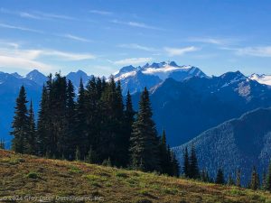
Located in the Sawtooth National Forest near Stanley, Idaho sits the Cecil D. Andrus-White Clouds Wilderness. It is a truly spectacular place with views that can rival the best in the United States. Due to distances and terrain, it is difficult to penetrate all but the perimeter on a day hike. The best way to visit is to backpack. There are certainly options for less demanding backpacks that pick up small, but beautiful, pieces of the area. If you want an epic backpack that covers a large swath of the area, however, the White Clouds Loop will blow your socks off.
A Couple of Notes about This Article and The White Clouds Loop Before We Begin
First, I apologize for the quality of the photographs in this post. Unfortunately, despite blue skies, huge wildfires in Idaho, Oregon, and California pumped massive amounts of smoke into the White Clouds area during our time there. In fact, it was so bad on our exit day, it almost seemed like we were in the middle of a forest fire. Please try to look past the smoke and imagine these majestic, eye-popping mountains and lakes on a clear day. Although the camera lens could not capture all we saw due to the smoke, the views the eye could see were nothing short of astounding.
Second, we did the White Clouds Loop in 3 days. This trip was too short. Because of some of the demands of the trip and the sheer beauty of the lakes and surrounds, we wish we took four or even five days to slow down and fully enjoy the White Clouds Loop. If I were to pick the sweet spot, at least for me, it would be a four day/three night trip.
Third, although this is a world-class backpack in a spectacular location, the first day of the hike was wrought with danger for all but very experienced, strong hikers with advanced backpacking and navigation skills. The first day required many miles of off-trail hiking, summiting a peak by climbing boulders and scree that was loose and unstable, and navigating a near vertical boulder field to get to Scree lake that frankly scared the hell out of us. Additionally, you are unlikely to see other backpackers doing this segment of the route and there is no cell coverage, so if you have an emergency, you must have the knowledge, skills, and safety equipment to deal with it within your group.
For the reasons just mentioned, we are not sharing the waypoints for the off-trail segment of this hike. They are available by internet search for those who believe they can handle this hike and are, like we were, committed to doing it. It is for those people that I am writing this article to share our experience so they know what to expect.
For the rest, please enjoy the read and look at this as a possible future target. In the interim, we will be writing some articles in the future about less demanding routes that will enable you to see beautiful segments of this trip, without taking the risks associated with day 1 of this amazing hike.
Day 1 of the White Clouds Loop: Fourth of July Trailhead to Scree Lake
Starting at the Fourth of July Trailhead near Stanley, Idaho at an altitude of roughly 8,750′, we set out to hike the White Clouds Loop and our initial target of 9.6 miles to Shelf Lake. Unfortunately, we fell willfully short. Due to the difficulty of the terrain (virtually all boulders, rocks, and scree), the need to carefully pick our route, and the need to make sure Mac and I were not directly above/below each other due to the potential of falling rocks on descents and ascents, we only covered 6 miles in the 8 hours we hiked on day one.
From the Fourth of July Trailhead, we hiked the 1.4 miles on the Washington Lake Trail to the junction with the Antz Basin Trail, taking that trail towards the Born Lakes. After only about .5 miles, we reached a small unnamed lake below Patterson Peak. This is where the off trail portion of our trip began.
Finding a starting point for the route up and over the 10,872′ Patterson Peak was somewhat difficult even with waypoints. Eventually, we committed and began our climb on loose boulders and scree toward a small clump of tress on the ridge leading up to the summit.
Once on the ridge, we began moving through the boulders to the summit of Patterson Peak. We had a waypoint for the “true summit” where we would begin our descent, but the peak is somewhat confusing to navigate and we were traveling on a knife’s edge ridge with huge drops on either side and winds that were likely 40-50 miles per hour.
Eventually reaching the true summit of Patterson, we began our descent to continue the White Clouds Loop. The descent was, in a word, treacherous. Aside from the boulders, there was a huge amount of loose scree and the pitch of the slope was very steep. With each step, our boots would slide downward, requiring great care and heavy use of trekking poles, while still at times falling on our butts.
With time, we made it to the bottom of the back side of Patterson, arriving at the Four Lakes Basin. Here we sat between Emerald Lake and Rock Lake eating lunch, taking in the beautiful scenery, and discussing the exhilarating, but scary, ascent and descent over Patterson Peak.
After a short lunch, we began moving again towards our target of Shelf Lake, thinking the worse was behind us. Unfortunately, we were wrong, but more about that in a minute.
We proceeded through the rocky and beautiful Four Lakes Basin and headed to Quiet Lake. Here we encountered the first people we saw after leaving the Antz Basin Trail. Quiet Lake is a gorgeous lake with a few good campsites. We said ‘hi’ to a handful of backpackers as we moved through the sites on a goat path along the lake, still off-trail. (No trails lead to Quiet Lake, but it is possible to get there traveling in the opposite direction than we traveled without going over Patterson. To do so, however, requires a very long out & back, as well as a few miles of off-trail hiking. This is how the other backpackers reached the lake.)
At the far end of Quiet Lake, one must hike up hill to Scree and Shallow Lakes to ultimately reach Windy Devil Pass and the beginning of established trails. Even with way points to navigate, this was no easy task and here we encountered the truly scary part of our journey around the White Clouds Loop.
To get up to Scree Lake, we shot a compass line to our waypoint for the lake access. (Note: I’ve seen one account, and only one, of a faint footpath leading to Scree Lake. We could not find it, so we relied on waypoints and compass instead.) The terrain was very steep, so we tried to stick to small slivers where there was some vegetation growth that stabilized the boulders and scree. Eventually, however, there was no option other than to enter the pure boulder fields.
Heading up the boulders was scary as hell. Not only was the pitch close to vertical, massive boulders were moving under our feet as we climbed. With trekking poles stored so we could be on all fours, we worked our way up the slope, making sure I, in the lead, was never above Mac due to falling rocks. Believe me, this ascent was no joke.
We spent quite a bit of time navigating our ascent. We assessed and started a couple of routes, only to find gaining the top was too dangerous to proceed. Eventually, we did find a way to access the top and Scree Lake.
Scree Lake is a beautiful setting and, because is was 5 pm, the sun was sparking the peaks at the backside of the lake. Of course, after 8 hours of hiking with the challenges detailed above, we were exhausted (we are 60 after all!).
We decided to camp at Scree for safety, falling 3.6 miles short of our intended target. To add to the frustration, the ground was almost all scree and vegetation. To lessen our impact on the vegetation, we pitched our tents on a narrow goat path. It was not ideal, but sometimes safety considerations win out.
After eating dinner (and having a couple of shots of Captain Morgan!), we called it a night at 7:00 pm. We would have a lot of mileage to make up the next day and rest/recovery was paramount – plus, it was freezing outside, so why not climb into a nice, warm down sleeping bag?
Day 2 of the White Clouds Loop: Scree Lake to the Chamberlain Lakes Basin
Waking up at 6 am on day two refreshed, we ate a quick breakfast and packed up. Because we fell 3.6 miles short of our goal the day before, we would have to make up the shortfall today, backpacking 12.6 miles on rugged terrain to get to our target of the Chamberlain Lakes Basin. Still off trail, our first task was to navigate to Windy Devil Pass, where we would get back to hiking on established trails to finish the White Clouds Loop.
Navigating the 1.5 miles of off-trail hiking to Windy Devil Pass was a little tricky. Fortunately, the route, although steep, had enough vegetation to stabilize the boulders and scree. This, together with a good night’s sleep, let us cover the distance in a reasonable amount of time. Along the way, also we had the pleasure of watching a couple of mountain goats as they moved along the rocks near us.
Reaching Windy Devil Pass, two emotions struck us. The first, of course, was the joy of reaching a defined, although boulder and scree filled, trail. The second was the amazement of looking down at the Boulder Chain Lakes, one of the main attractions of the White Clouds Loop.
The basin holding the Boulder Chain Lakes is astonishingly beautiful. From the top of Windy Devil Pass, very high above the basin, the lakes lay out in front of you with an incredible view of Scoop, Headwall, and Hummock lakes below.
The descent from the top of Windy Devil Pass on the Boulder Chain Lakes Trail is rugged. The entire hike is on a faint rock trail descending a boulder field. At least with a defined path, however, the descent moves relatively quickly.
Upon reaching the bottom, we began a fantastic hike through the Boulder Chain Lakes. This segment, in particular, was why I wish we had planned a 4 day, instead of a 3 day, trip. The lakes are jaw dropping gorgeous and I wish we had a full day there to linger and explore the roughly 8 lakes we passed along this stretch of trail. Trust me, if you backpack the White Clouds Loop, leave a full day and one night to hang and explore the lakes.
At the end of the Boulder Chain Lakes Trail, we reached the Livingston Mill-Castle Divide Trail. Turning right to continue the White Clouds Loop, this trail would take us all the way to the Chamberlain Creek Trail and the Chamberlain Lakes Basin.
The first stretch of this trail was pretty boring, but at least it was dirt rather than the boulders and scree that made up all of the hiking to this point. The trail here is wooded and somewhat pretty, but it is a double track that allows dirt bikes, so it was fairly torn up.
Emerging from the woods, we crossed a field before hitting a junction with Trail 682 that goes off to the left, taking dirt bike access with it. (Note that this junction is the last water for the next 4 miles, so make sure you have an ample supply.) Turning right to stay on the Livingston Mill-Castle Divide Trail, we re-entered the forest and begin climbing, surrounded by the beauty that makes the White Clouds Loop so enchanting.
Here we began our climb up towards Castle Divide, an amazing pass with incredible, giant rocks that shoot up from the hillside. The climb is steep, but most of it is on dirt as opposed to scree, so we were able to move quickly to the pass.
The climb was incredibly beautiful and dramatic along the very steep hillside. I virtually never suffer from vertigo, but I will say that the views were so extreme they were almost dizzying. What an amazing experience!
Reaching the Castle Divide pass at roughly 10,000′, we found some large boulders at the top which offered a great place to take a break and soak up the incredible views of the surrounding peaks.
After resting and taking in the surrounds, we began our descent to the Chamberlain Lakes Basin. Along the way, there were short climbs and descents, but the overall trend was down with good footing, making the hiking fast and enjoyable.
At 12.6 miles from Scree Lake, we reached the first lake in the Chamberlain Lakes Basin. The lake had a number of great camping sites and, with no other backpackers at the lake, we chose the choicest site. It was about 3:00 when we arrived.
After setting up camp, we sat by the lake soaking in the gorgeous views of the peaks around the lake. Around 4:30 pm, on the other side of the lake a herd of six mountain goats came down to the water’s edge. The young goats played with each other and in the water, while the older ones supervised. It was truly a heart warming experience.
After sitting by the lake enjoying nature until the sun went behind the peaks, we moved back to our camp about 30 yards from the water’s edge, ate dinner, and headed to our tents to sleep. It was a great day.
Day 3 of the White Clouds Loop: Chamberlain Lakes Basin to Fourth of July Trailhead
Waking up the morning of day 3 on the White Clouds Loop to the beauty of the Chamberlain Lakes Basin started the day off right. As the sun rose, it reflected off the surrounding white peaks that give the White Clouds their name. We took a beat to have a nice cup of coffee and breakfast while enjoying the views before breaking camp and heading out on our exit hike.
Day 3 of the White Clouds Loop was pretty, but did not offer the jaw dropping views afforded by days 1 and 2. A large part of the difference was a tremendous amount of smoke flooding in on the prevailing winds, which obscured many of the views. That said, the White Clouds, even in these conditions, can still stand toe to toe with some of the best mountain scenery in the U.S. As all backpackers know, when you are on a multi-day trip, you get what the weather brings.
Despite the smoke, the Chamberlain Lakes Basin still offered a great deal of beauty because many of the peaks circle closely around the lakes. As we exited the basin and began the 8.5 mile hike back to the Fourth of July Trailhead, we said goodbye to the Basin’s views and began moving through fairly diverse and changing scenery.
Picking back up the Livingston Mill-Castle Divide Trail, we hiked 3.4 miles to the Washington Lake Creek Trail. As we traveled the 3.4 miles, the trail ascended and descended a number of times as it went through a couple of passes. We also traveled through a large burn area created by the Bible Back Fire of 2018. The burn area had an an eerie feel due to the burned trees and the heavy smoke in the air. The burn area also gave us many, many beautiful wildflowers to enjoy, greatly enhancing the hike.
After 3.4 miles, the Livingston Mills-Castle Divide Trail reached the junction with the Washington Lake Creek Trail. Taking a right, we traveled the remailing 5.1 miles back to the Fourth of July Trailhead. Although the trail here is not as exciting as the rest of the White Clouds Loop, it did hold some gems.
The Washington Lake Creek Trail changed scenery pretty regularly. It passed through some pretty forested areas, into open grassy areas, and through some barren stretches past small tarns. Further down the trail, we passed Washington Lake. Washington Lake is a large lake with a dramatic back drop as a high ridge rises above the lake.
It was at Washington Lake that saw people for the first time that day. Being only about 2.5 miles from the trailhead, the lake is easily accessible for day hikers. The sight of these people was a clear indication to us that our trip along the White Clouds Loop was coming to an end.
A little further down the Washington Lakes Creek Trail, we passed Fourth Of July Lake. The lake is much smaller than Washington Lake, but I think it is the far prettier of the two due to its relative gentle feel. After passing the lake, we reached the junction with the Antz Basin Trail, where we began the White Clouds Loop, and hiked the remaining 1.4 miles back to the trailhead.
Shortly before noon, we reached the Forth of July Trailhead, having completed the demanding, but incredibly rewarding White Clouds Loop. It was an awesome backpacking trip I will always cherish.
Final Thoughts about the White Clouds Loop
The White Clouds Loop is truly a world-class backpack. The scenery is amazing, wildlife spotting opportunities abound, the terrain is rugged and unique, the lakes are drop dead gorgeous, the adventure of the off-trail portion of the trip is crazy, and other hikers are sparse to none. For those who have advanced backpacking and navigation skills, it’s a great trip. The one change I would make, as stated earlier, would be to add a fourth day to the trip to allow a slower pace to enjoy the loop. Other than that, I can’t wait to get back there to do it again – hopefully, without all the smoke!
Scroll down to learn about the GEAR WE USE and OTHER OUTVENTURES in this area.
Additional Information (Click below to follow links.)
White Clouds Loop Slideshow
(Click image to expand.)
Gear We Use for Backpacking
To see descriptions of the gear Chris & Mac use for backpacking, as well as links to manufacturers and retailers offering the gear for sale, please CLICK HERE.

Articles About Other Regional Outventures
SAFETY DISCLAIMER: The activities discussed in this website are outdoor activities and, as such, have inherent risks to which participants are exposed. It is not the intent of this website, nor is it possible due to the variability of weather, terrain, equipment, and experience, to detail all of those risks. The information contained in this site is informational, but not instructive nor exhaustive. It is the sole responsibility of the user to ensure he/she is in good health, fully prepared, and fully informed as to dangers before undertaking any of the activities discussed in this website and the user does so at his/her own risk. The user understands that by using this website he/she acknowledges and accepts all risks associated with use of information from this website and participation in any particular activity addressed herein. Please see “Terms of Use” for additional information.
Want to share this article with your friends? Click on the share button below:
Want more?
Get the latest outventure updates by following us on social media . . .