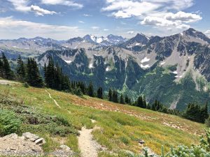
Backpacking the Alice Toxaway Lakes Loop through Idaho’s rugged Sawtooth Mountains is a memorable adventure filled with amazing scenes of beauty.

Chris & Mac
We outventure to help you outventure!
For us, outventuring isn’t just about adventure. It’s about the quiet moments — the first light on a ridgeline, the sound of a creek at camp, the shared laughter when the trail gets spicy. We believe the outdoors enriches people’s lives, and we want to help more folks experience that connection. Learn more about us HERE.
Scroll down for full slideshow.
Length: 19.17 Mile Loop
Trailhead(s): Tin Cup Hiker Trailhead
Elevation Gain: 2,931’
Trail Type: Loop
Dogs: Allowed
Difficulty: Moderate
Permit Required? Yes – Wilderness Permit Required; Free -Self Issue on Trail
Considerations: Lingering Snow
Season: Summer -Early Fall (Best)
Overview
Backpacking the Alice Toxaway Lakes Loop through Idaho’s rugged Sawtooth Mountains is a memorable adventure filled with amazing scenes of beauty that will stop you in your tracks over and over again.
TIN CUP HIKER TRAILHEAD
The starting point for this backpacking adventure is the Tin Cup Hiker Trailhead. Although there is a large parking area here, it is often full or nearly full by 9am in the busy summer months because backpackers keep it partially full around the clock. If the lot is full upon arrival, head back 1/4 mile to the overflow lot. Alternatively, snag a campsite at the Pettit Lake Campground (adjacent to the parking area – 12 tent sites) the day before hitting the trail, and you will surely find an open spot in the parking area first thing the next morning.
ALICE LAKE – TOXAWAY LAKES LOOP
The Alice-Toxaway loop is perfect for a two to three day backpacking trip in the Sawtooth Wilderness. The loop leaves the trailhead and follows the Pettit Creek Trail all the way up to Snowyside Pass. At the pass the Pettit Creek Trail terminates, and the loop continues on the Alice Lake-Hellroaring Lake Trail to where it bisects the Yellowbelly Trail at Toxaway Lake. The Yellowbelly Trail then descends to the Pettit Lake Cutoff Trail which returns backpackers the trailhead. We spent two days backpacking this loop, camping for one night at Toxaway Lake. Backpackers who take three days for the loop generally spend one night here and one night at either Alice Lake or Twin Lakes.
Pettit Creek Trail to Alice Lake
Pick up the Pettit Creek Trail behind the trailhead signage and relish the views while walking past lovely Pettit Lake. On a calm, clear morning the reflections of McDonald Peak in the water are stunning. Did we stop a few times to take it in? Yes we did! Beyond the lake the trail rolls through lovely forest while climbing relatively easily. Glimpses of white rock walls above the trees hint at the spectacular beauty that lies ahead. We stopped several times to take pictures.
Once the trail enters a meadow area below Parks Peak the trail ascends via switchback. Stop as we did to take a couple of breathers and turn around – the views are gorgeous. Seriously, don’t miss them. Following the switchbacks there are areas of flatter trail as well as some steeper short sections, a lot of rock, and some stream crossings. The climb is persistent, but any discomfort is forgotten upon reaching the beautiful unnamed tarn before Alice Lake. It so gorgeous we once again were stopped in our tracks. Some mistake this tarn for Alice Lake. It is NOT Alice Lake. Relish the scene and the break from climbing along this flat stretch of trail as it rolls past this lovely tarn and Alice Lake.
Follow one of the foot paths off the main trail at Alice Lake for a much deserved break before continuing on the Alice-Toxaway loop. If staying here, there are numerous campsites scattered around. There are lots of lovely rocks offering outstanding vantage points to soak in the magnificent scene, and campsites are scattered about. About half way past Alice Lake the trail moves away from the lake and starts climbing again. After another 400 feet of elevation gain over about a mile it intersects the short spur trail leading down to Twin Lakes.
Snowyside Pass
From the spur down to Twin Lakes the climb up to Snowyside Pass is another 500 feet of gain over a mile. After emerging from tree cover the trail continues climbing to the pass on open, rocky slopes. The eagles eye view of Twin Lakes sitting beneath classic Sawtooth peaks is stunningly magnificent We stopped a few times on the way to admire Twin Lakes, and at the top of the pass we stopped in our tracks once more. Two gorgeous unnamed tarns were visible in the valley far below – the nearer, larger one was a striking dark blue color and the smaller one beyond it was a vibrant aqua blue. The two mile journey down the rocky switchbacks on this portion of the Alice-Toxaway loop was superb.
We passed a group of backpackers hiking up to Snowyside Pass from the opposite direction. We recognized them as the joyous group we saw departing from the trailhead as we were preparing to head out. Honestly, some of them looked pretty miserable now. Their climb up to Snowyside Pass was strenuous, they had already logged many miles of climbing, and with about a mile of steep switchbacks to go some of them were obviously very fatigued. Seeing them affirmed our choice of direction.
Toxaway Lake
The rest of the Alice-Toxaway loop hike our first day took us right past the lovely tarns we saw from Snowyside Pass. The trail maintained a downward trend, however the tree and rock terrain was much more rolling in nature than we experienced on the other side of the pass. Following a foot path off of the main trail as we neared Toxaway Lake, we quickly located a fantastic campsite. The site allowed us to look back towards Snowyside Peak as well as out towards where we would head the next day. The rocks were great for hanging out, and we had no trouble finding level areas for our tents. Perhaps the best part of camping at Toxaway Lake was that it was not busy. There were only a few other backpackers there that night. We were barely aware that we were not alone, and it was very peaceful.
Back to the Tin Cup Hiker Trailhead
The second day of the Alice-Toxaway loop took us back along the Yellowbelly Trail, past Bowknot Lake, some other small tarns, and Farley Lake. It was a lovely descent that included streams and water cascading down over the rocks between the lakes. The scenery was pretty and the views were very nice as well. After picking up the Pettit Creek Cutoff Trail a bit before Yellowbelly Lake, we encountered about a mile of ascent with not much to look at before descending to the Pettit Creek Trail. After that it is a quick hike back to the trailhead.
DIRECTION OF TRAVEL ON THE LOOP
All three lakes (Alice, Twin, and Toxaway) have established campsites, and all of the lakes are beautiful. Because the Alice-Toxaway loop can be hiked either clockwise or counterclockwisewe saw backpackers moving in both directions. Our preference, however, is to backpack this loop clockwise. Because this is a loop the elevation gain and loss is the same, however the direction of travel yields different experiences.
Clockwise Travel
We backpack the Alice-Toxaway loop clockwise for four reasons. One, since we hit the trail in the morning this direction keeps the sun at our backs instead of in our eyes. Two, the easy 2 mile flat stretch of trail gets our legs warmed up before the trail begins ascending. Three, the worst part of the climb comes while our legs are still fresh. Finally, the serious climbing is completed less than half way around the loop.
Hiking clockwise, all of the best views are in front of us when the morning sun shines on them. With all of the magnificence before us not in shadow we get to really see it, and the lighting is perfect for photos. Not only is the light good, but we are not yet fatigued when we reach the most strenuous part of the trail when it opens up the views in the meadows below Parks Peak. Finally, summiting Snowyside Pass is much, much easier when traveling clockwise on the loop.
Counterclockwise Travel
Heading counterclockwise, backpackers experience this loop much differently. Rather than a 2 mile flat warm up there is an immediate 1 mile up and 1 mile down right out of the gate. After a fairly flat mile the trail then makes a steady climb for about 4 miles up to the shores of Toxaway Lake. The most grueling part of the loop is still ahead, however, and it comes after Toxaway Lake: The 2 mile steep climb up the scree and rock switchbacks to Snowyside Pass.
Which way to go?
Other than the lighting issues mentioned above, the real difference in how the Alice-Toxaway loop is experienced really depends on two factors. One is whether it is being completed over 2 days or 3 days. The other is where to camp. Frankly, we wouldn’t consider backpacking this loop counterclockwise unless we were doing it over three days. That would allow for a nice rest at Toxaway before heading up the grueling switchbacks to Snowyside Pass. Even then, we would still choose clockwise not just to avoid ascending these particular switchbacks, but also because descending from Parks Peak in the morning we would be hiking with the sun in our eyes rather than at our backs.
On a two day trip it makes sense to split the total distance in half over a two day adventure. That means definitely camping at Toxaway Lake or travelling farther on one of the two days. On a three day outing we would choose to camp at Twin Lakes and Toxaway Lake. Alice Lake is spectacular, but is not as peaceful because it gets day hikers, backpackers, and equestrian visitors. As such, it offers less quiet, less privacy and little solitude.
Scroll down to learn about the GEAR WE USE and OTHER OUTVENTURES in this area.
Additional Information (Click below to follow links.)
Backpacking Alice-Toxaway Lakes Loop Slideshow
(Click image to expand.)
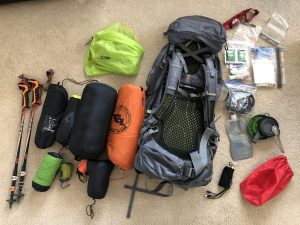
Gear We Use for Backpacking
To see descriptions of the gear Chris & Mac use for backpacking, as well as links to manufacturers and retailers offering the gear for sale, please CLICK HERE.

Articles About Other Regional Outventures
SAFETY DISCLAIMER: The activities discussed in this website are outdoor activities and, as such, have inherent risks to which participants are exposed. It is not the intent of this website, nor is it possible due to the variability of weather, terrain, equipment, and experience, to detail all of those risks. The information contained in this site is informational, but not instructive nor exhaustive. It is the sole responsibility of the user to ensure he/she is in good health, fully prepared, and fully informed as to dangers before undertaking any of the activities discussed in this website and the user does so at his/her own risk. The user understands that by using this website he/she acknowledges and accepts all risks associated with use of information from this website and participation in any particular activity addressed herein. Please see “Terms of Use” for additional information.
Want to share this article with your friends? Click on the share button below:
Want more?
Get the latest outventure updates by following us on social media . . .