Length: 6 Miles Round Trip
Trailhead(s): Access via Lower Calf Creek Campground Parking Area
Elevation Gain: Minimal – Approximately 200′
Trail Type: Out & Back
Dogs: Allowed on Leash
Difficulty: Easy to Moderate
Permit Required? Yes – $5 Parking Fee or Interagency Park Pass
Considerations: Summer Heat & Bugs; Sand
Season: Year Round
Overview
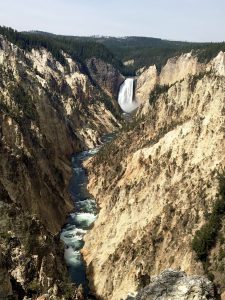
History and beauty are abundant along the Grand Staircase Escalante National Monument Lower Calf Creek Falls Trail. Leading hikers through a lush desert canyon filled with abundant wildlife, gorgeous vegetation, and evidence of ancient human activity, the trail culminates in a magnificent 126 foot waterfall and swimming hole that are absolutely gorgeous. This hike is a must do if you are in the area.
HIKING LOWER CALF CREEK FALLS TRAIL
Accessing Lower Calf Creek Falls Trail
Departing the parking area, follow the road about 300 yards past the campground to reach the well marked trailhead. Sign in and pick up a copy of the trail brochure which explains the fifteen interpretive stops found along the trail which begins with a small climb up the rocks behind the signage. Similar minor elevation changes like this are encountered numerous times on the trail as it follows the creek on the west side of the canyon.
Lower Calf Creek Fall Trail Features
Rocks turn from red to white as the Lower Calf Creek Falls Tail goes deeper into the canyon, highlighting its geologic history. Proximity to the creek determines whether vegetation is low, scrubby, and sparse or luxuriously thick and vibrant. Throughout it all, however, the trail surface alternates between sand and rock. Changes in the canyon are truly remarkable, so focus on observing them as you hike and try to ignore the sand. It comes and goes.
Definitely take time to stop at each of the interpretive markers and pull out the trail brochure. Unlike other trails with interpretive trail signage, this trail uses a simple system of markers. Because the points of interest are marked only with numbered wooden posts the brochure explains what to look for at each one. If the sighting is not immediately obvious, keep looking. For example, it took us several minutes to see the pictograph figures on the opposite side of the canyon because they are orange and blend into the scenery.
At the end of the hike, enjoy the breathtaking beauty of Lower Calf Creek Falls and its surrounds. Pack a snack or a lunch because you will want to spend some time here either enjoying cooling off or just soaking it all in.
Lower Calf Creek Falls Trail Observations
We hiked the Lower Calf Creek Falls Trail in October with our dog. Temperatures were pleasant, the trail was not crowded, and the fall foliage was glorious. Spring and summer hikers here will find lots of green foliage, beautiful wildflowers, bugs, and plenty of other hikers. If trail traffic is an issue for you (we prefer to avoid crowded trails when possible), mid-week usage is generally lighter than on weekends. Try to time your hike to avoid peak times and peak heat. Thus, if hiking here in the summer be aware that this is a hot hike. Although there is spotty shade along the trail there is also a lot of trail with no shade at all. Even with the waterfall and swimming hole to cool off, there is still a three mile hike back to the parking area. Avoiding the hottest part of the day is advisable.
Scroll down to learn about the GEAR WE USE and OTHER OUTVENTURES in this area.
Additional Information