Hike to the top of Mount Washburn from Dunraven Pass and enjoy outstanding views, wildlife encounters, and seasonal wildflowers.

Chris & Mac
We outventure to help you outventure!
For us, outventuring isn’t just about adventure. It’s about the quiet moments — the first light on a ridgeline, the sound of a creek at camp, the shared laughter when the trail gets spicy. We believe the outdoors enriches people’s lives, and we want to help more folks experience that connection. Learn more about us HERE.
Scroll down for full slideshow.
Length: 6.4 Miles Round Trip
Trailhead(s): Washburn Trailhead at Dunraven Pass
Elevation Gain: 1,400’
Trail Type: Out & Back
Dogs: Not Allowed
Difficulty: Moderate to Strenuous
Permit Required? Yes – National Park Entrance Fee or Valid Park Pass
Considerations: High Elevation Hike; Seasonal Road Closures; Grizzly Bear Feeding Area in Fall
Season: Year Round; Best in Summer
Overview
Take a hike to the top of Mount Washburn for wildlife encounters, wildflowers, and incredible views of Yellowstone National Park.
MOUNT WASHBURN
Located in the northeastern section of Yellowstone National Park, Mount Washburn stands a whopping 10,243 feet tall. This is according to the park’s website. When we visited here, however, the sign at the top indicated an elevation of 10,219 feet. This 24 foot discrepancy is a mystery – did the mountain grow, or was the signage changed to correct an error? We may never know.
Either way, Mount Washburn is tall. As such, it is home to one of the three fire lookout towers in Yellowstone National Park. During fire season this lookout is staffed 24/7 by firefighters who look for, report, and monitor park fire activity. They live atop the mountain in a one room space on the fire lookout. Check out this quick two minute video which explains their work and shows the accomodations. It’s pretty cool.
Thus this vertically endowed peak plays an important role in protecting the park, its inhabitants, and its visitors. Aside from this, however, it is also a really cool place to take a hike.
Hiking Mount Washburn – Two Routes
Two popular routes lead up to the top of Mount Washburn for day hikers. A third route, which is primarily a backpacker route, climbs up from the Glacial Bolder Trailhead.
Because the day hiker routes both lead to the same place, is one “better” than the other? Well, here’s the scoop: its a matter of opinion. The one from Chittenden Road is shorter (2.5 miles one way), but steeper than the trail up from Dunraven Pass (3.2 miles one way). Because each of them gain roughly the same on the ascent (provided each is open and accessible), you get to choose your battle. A little more distance or a little bit steeper climb? In other words, distance vs steepness is the primary tradeoff.
Aside from the distance and steepness differences, the route up from Dunraven Pass is more popular, and a little more scenic. The only other difference is that bicycles are allowed on the route up from Chittenden Road, but they are not permitted on the Dunraven Pass route. We followed the trail up from Dunraven Pass, and had a thoroughly enjoyable hike.
DUNRAVEN PASS TO MOUNT WASHBURN SUMMIT
From the Dunraven Pass parking area, the trail is a rocky road to the top of Mount Washburn. It is a steady, relentless climb on a wide path the entire way to the summit.
Mount Washburn – Below the Treeline
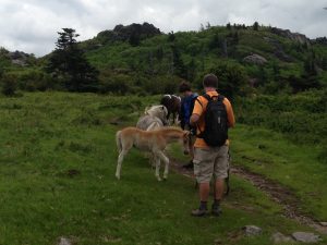
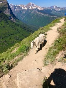
For the first couple of miles see what you can find in the way of flora and fauna as you hike up through open meadows and forested areas. We came across a couple of mountain goats lazily grazing in the trailside foliage. Interestingly, they paid us little mind, obviously desensitized to the presence of humans in their home. We were clearly much more impressed by them than they were by us!
Otherwise, look for wildflowers that blanket the hillsides in mid-summer. A a well timed hike here (July) has great payoffs in that respect. We hiked here in August and missed the big show, but some later varieties were still fiercely blooming.
Mount Washburn – Above the Treeline
Tree cover and other vegetation at the trailhead fade away when the trail reaches the ridge that runs from Dunraven Peak to Mount Washburn. This occurs about two and a quarter miles from the trailhead. At this point only the north and west side of the ridge has trees. In contrast, the east and south facing side has very light vegetation and a whole lot of rock. Consequently, when the trail reaches this ridge, the views to the south and east open up, and they stay that way.
Hiding in full view here is the top of the Grand Canyon of the Yellowstone. Even though we can only glimpse this tiny bit of it, we have great views of it throughout the rest of the hike and from the summit of Mount Washburn. As an aside here, take time to hike it if you can – it is fabulous!
Nearing the summit, the trail ascending from Chittenden Road ties in as does the backpacker trail. Stay left and the wide path will circle around the peak. At its end it deposits hikers on a large, flat area at the summit. In addition to the fire tower lookout there are restrooms and an enclosed viewing area. Enjoy the views from the summit. Wander around, sit and stare, and take it all in. Not only is there plenty of room for everyone to spread out, there is an awful lot to look at.
Mount Washburn Weather and Other Matters
Before departing the trailhead, be sure you are well prepared for what you are about to hike. These are important words of caution which should be heeded by everyone hiking to the top of Mount Washburn.
Mountain weather is fickle and conditions up top are always different than at the trailhead. As such, bring a jacket or other warm layers with you. Even on a warm day, this is an elevation hike and it is always cooler, and most often quite windy up top. Additionally, be sure you have an adequate supply of water when you set out from the trailhead. This is because there is no access to water until you reach the summit. Finally, pay close attention to the weather because this is a high elevation exposed hike. As such, lightening can be an issue, especially above the treeline. Hiking here during a lightening storm is ill advised.
On a final note, be bear aware and bear safe when hiking to the top of Mount Washburn. This is always true in Yellowstone National Park, but particularly when hiking Mount Washburn in September and October. This is because grizzly bears preparing for winter frequent the slopes around Mount Washburn in search of whitebark pine nuts. It is still possible to hike here, however the park service does discourage it during this time because of the bears. Therefore, if you hike Mount Washburn in the fall, be extra vigilant and be prepared. The park offers tips and guidance about bear safety – a link to this information is provided below.
Scroll down to learn about the GEAR WE USE and OTHER OUTVENTURES in this area.
Additional Information (Click below to follow links.)
Mount Washburn Slideshow
(Click image to expand.)
Gear We Use for Day Hiking
To see descriptions of the gear Chris & Mac use for day hiking, as well as links to manufacturers and retailers offering the gear for sale, please CLICK HERE.
Articles About Other Regional Outventures
SAFETY DISCLAIMER: The activities discussed in this website are outdoor activities and, as such, have inherent risks to which participants are exposed. It is not the intent of this website, nor is it possible due to the variability of weather, terrain, equipment, and experience, to detail all of those risks. The information contained in this site is informational, but not instructive nor exhaustive. It is the sole responsibility of the user to ensure he/she is in good health, fully prepared, and fully informed as to dangers before undertaking any of the activities discussed in this website and the user does so at his/her own risk. The user understands that by using this website he/she acknowledges and accepts all risks associated with use of information from this website and participation in any particular activity addressed herein. Please see “Terms of Use” for additional information.
Want to share this article with your friends? Click on the share button below:
Want more?
Get the latest outventure updates by following us on social media . . .