For a fun adventure with astounding views, take a hike to Spray Park and escape the busier Sunrise and Paradise areas of Mount Rainier National Park.

Chris & Mac
We outventure to help you outventure!
For us, outventuring isn’t just about adventure. It’s about the quiet moments — the first light on a ridgeline, the sound of a creek at camp, the shared laughter when the trail gets spicy. We believe the outdoors enriches people’s lives, and we want to help more folks experience that connection. Learn more about us HERE.
Scroll down for full slideshow.
Length: 8.6 Miles Round Trip *
Trailhead(s): Spray Park Trailhead at Mowich Lake
Elevation Gain: 1,850’
Trail Type: Out & Back
Dogs: Not Allowed
Difficulty: Moderate
Permit Required? Yes – $35 National Park Entry Fee or Annual Pass Plus Timed Entry Permit (Beginning 2024, Follow this Link for Details)
Considerations: Lingering Snow
Season: Summer
* The entire Spray Park Trail is roughly 14.5 miles round trip
Overview
A hike to Spray Park offers solitude and gorgeous scenery – minus the summer crowds of the busier Sunrise and Paradise areas of Mount Rainier National Park.
MOUNT RAINIER
At 14,410 feet above sea level Mount Rainier is the tallest of the volcanic peaks in the Cascade Mountain Range, and this gorgeous giant has an astounding 25 major glaciers. Within the continental United States no other mountain has as many glaciers as Mount Rainier. Besides its beautiful glaciers, Mount Rainier also has many permanent snow fields. This gorgeous mountain gets a lot of snow. It gets so much that many of its roads close as soon as the snow comes in the fall, and they stay closed until they are once again safe to travel. The snow closes the trails too, and it is often into the summer before they are open again, especially at higher elevations.
Even though it takes more time for the snow on the roads and trails at the higher elevations of Mount Rainier to clear, the lower elevations clear faster. As such, they are the first areas of Mount Rainier National Park to open. Once they do, visitors start flocking to Mount Rainier because it is a majestically beautiful mountain that adventurers and nature lovers can’t wait to explore each summer.
Hiking Mount Rainier
The easy to get to trails at lower elevations get a lot of foot traffic as soon as they are opened by park staff. As the snow melt moves up the mountain, more trails become accessible. Some of these trails are short, others are long. Some are easy, some are hard. No matter what type of adventure they have in store for visitors, the one thing that many of them have in common is that they are easy to access. As such, these trails get very busy.
Unfortunately, this popularity compromises the wilderness experience sought after by many who visit Mount Rainier. Thus those seeking solitude often seek out remote areas of the park which are not as easy to access and therefore don’t attract as many visitors. One such area which is incredibly beautiful, and peaceful, is Spray Park.
HIKE TO SPRAY PARK
Visitors access this trailhead after entering the park at the Mowich Lake Entrance and traveling about 6 miles on a rough and bumpy gravel road. After arriving at Mowich Lake, the hike to Spray Park starts off on the Wonderland Trail where it passes through the entrance to the campground.
Eagle Cliff & Spray Falls
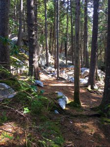
After a short walk out from the Mowich Lake trailhead, the Wonderland Trail intersects the Spray Park Trail. The Wonderland Trail continues off to the right, so take a left here to hike to Spray Park. Because the trail runs entirely in the forest initially there aren’t any views at all until hikers reach Eagle Cliff. A spur trail there leads out to stunning views of Mount Rainier. Do not miss this! After a little under two miles, at the start of a series of switchbacks, there is a short (.1 mile) spur trail which leads out to Spray Falls. Check it out if you like, and then return to the main trail.
Echo Rock, Observation Rock and Mist Park
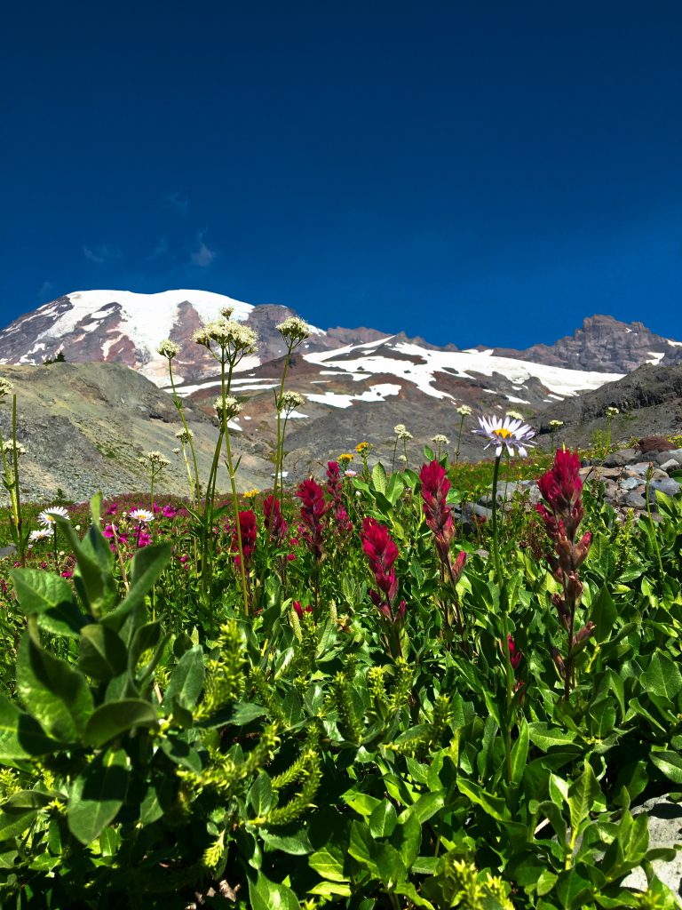
After Spray Falls, the trail quickly switchbacks up about 300 feet alongside Grant Creek for about a quarter of a mile. Although the switchbacks disappear quickly, the ascent continues another 1,300 feet or so before the trail tops out. Before long, however, the trees finally give way to higher elevation meadows, the ascent stops, and the views are spectacular.
The sight of Echo Rock and Observation Rock, with Mount Rainier looming large in the background behind them is unforgettable. For identification purposes, Echo Rock is the one with a very jagged crown like top whereas Observation Rock is a smooth triangle jutting up. After about 4 miles out from the trailhead, a side trail on the left leads down to views of Mist Park. We opted to stop here, enjoying the gorgeous views while eating our lunch before turning around to head back to Mowich Lake. The trail does continue on for roughly 3 more miles, however, to where it intersects the Wonderland Trail near the Carbon River Campground.
Fragile Meadows
The meadows encountered on our hike to Spray Park are beautiful. They are also extremely fragile and easily damaged by careless footsteps. When hikers tromp off trail in search of a better view they walk on these fragile plants. The views they find on these side jaunts are no better than those from the main trail, and these off trail wanderings have caused damage to these meadows. Because stopping the footsteps allows these wounds to heal, park rangers have taken measures to block off these foot paths. We hope everyone who hikes this trail will do their part to help nature repair these wounds by staying on the main trail through these meadows.
Scroll down to learn about the GEAR WE USE and OTHER OUTVENTURES in this area.
Additional Information (Click below to follow links.)
Spray Park Trail Slideshow
(Click image to expand.)
Gear We Use for Day Hiking
To see descriptions of the gear Chris & Mac use for day hiking, as well as links to manufacturers and retailers offering the gear for sale, please CLICK HERE.
Articles About Other Regional Outventures
SAFETY DISCLAIMER: The activities discussed in this website are outdoor activities and, as such, have inherent risks to which participants are exposed. It is not the intent of this website, nor is it possible due to the variability of weather, terrain, equipment, and experience, to detail all of those risks. The information contained in this site is informational, but not instructive nor exhaustive. It is the sole responsibility of the user to ensure he/she is in good health, fully prepared, and fully informed as to dangers before undertaking any of the activities discussed in this website and the user does so at his/her own risk. The user understands that by using this website he/she acknowledges and accepts all risks associated with use of information from this website and participation in any particular activity addressed herein. Please see “Terms of Use” for additional information.
Want to share this article with your friends? Click on the share button below:
Want more?
Get the latest outventure updates by following us on social media . . .