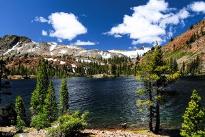
Hiking to Yellow Aster Butte in the Mount Baker Wilderness is filled with scenes of beauty that will take your breath away.

Chris & Mac
We outventure to help you outventure!
For us, outventuring isn’t just about adventure. It’s about the quiet moments — the first light on a ridgeline, the sound of a creek at camp, the shared laughter when the trail gets spicy. We believe the outdoors enriches people’s lives, and we want to help more folks experience that connection. Learn more about us HERE.
Scroll down for full slideshow.
Length: 7.6 Miles Round Trip
Trailhead(s): Tomyhoi/Yellow Aster Butte Trailhead
Elevation Gain: 2,458’
Trail Type: Out & Back
Dogs: Allowed
Difficulty: Moderate
Permit Required? Yes – $5 Day Use Fee (purchase) or Valid Recreation Pass
Considerations: Heavy Usage; Limited Parking
Season: Summer-Fall
Overview
Hiking to Yellow Aster Butte in the Mount Baker Wilderness is filled with scenes of beauty that will take your breath away.
YELLOW ASTER BUTTE
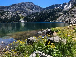
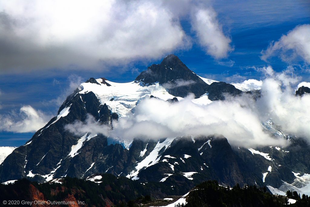
Three miles south of the Canadian Border in the Mount Baker Wilderness, Yellow Aster Butte sits in the middle of an astoundingly beautiful area. As such, hikers who ascend to its 6,241 foot summit are rewarded with unforgettably dramatic and eye popping views of the North Cascades. In fact, from the top of Yellow Aster Butte, the views are full on 360 degrees of panoramic magnificence. Not only can one look down upon beautiful lakes and valleys, but Mount Larrabee, Tomyhoi Peak, the American/Canadian Border Peaks, Mount Shuksan, and Mount Baker are all in full view.
The Tomyhoi Lake Trail #686
Hikers start off on the Tomyhoi Lake Trail to get to Yellow Aster Butte. This trail is steep, gaining nearly 1,500 feet over the first mile and a half. A quick climb into the trees from the trailhead is immediately followed by a long switchback on an open slope. This half mile stretch of the trail is surrounded by thick vegetation which is fortunately low enough to offer tantalizing peeks of Mount Baker. Transitioning into a steep relentless climb through the forest, these views completely disappear for the next mile.
When the trail emerges above the tree line, hikers depart the Tomyhoi Lake Trail and pick up the Yellow Aster Butte Trail. Lack of views and any discomfort on the climb up are quickly forgotten here. Not only does the trail flatten out to give hikers a break from climbing, but the gorgeousness of the area finally reveals itself.
The Yellow Aster Butte Trail #686.1
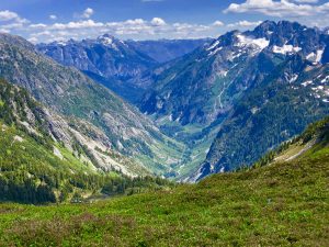
On the Yellow Aster Butte Trail we get our first taste of the incredible beauty of the area. As the trail passes first below Gold Run Pass and then beneath Yellow Aster Butte we are surrounded by incredible scenery. For example, when we hiked here in early August the hillsides were thickly blanketed with vivid wildflowers. In the fall, these same hillsides wear the glorious colors of autumn. This two mile stretch has little elevation change, so hikers get to simply walk through here and enjoy everything they see.
As the Yellow Aster Butte Trail works its way towards a huge wash area below Yellow Aster Butte, however, the landscape turns rocky and bleak. Because the beautiful vegetation disappears almost completely, this is quite a contrast from the terrain just travelled. In the event snow is still lingering in the wash – it was for us – the actual trail may be hidden. We noted a foot path through the snow that traversed the wash above the trail. However, since the trail was visible to us we followed it instead. It descends to the stream that flows through the wash, and then climbs back up on the other side of it.
Soon after the wash, vegetation and flowers take hold once again as the Yellow Aster Butte Trail makes a wide circle around Yellow Aster Butte. It climbs, although fairly gently, to approach it from the spine of Mount Tomyhoi. Throughout this part of the hike the views are simply amazing. Quite a few hikers had stopped at a rocky area below Yellow Aster Butte. It has great views, but honestly, those who turned around here missed some amazing scenery.
Yellow Aster Butte Summit
The final stretch of trail leading to the summit of Yellow Aster Butte is a doozy. It is very steep and rocky. No kidding. In places the trail is absolutely single file – awareness of self and others is critical. There are a few spots where hikers may need to find a stable place to “hang” because only one person at a time can safely navigate. These places are obvious, so just be alert in case others are also either ascending or descending this final stretch to or from the top. Hiking poles are your friend here – bring them and use them!
It is nearly impossible to describe the feeling of standing on the summit of Yellow Aster Butte. Mount Larabee and Tomyhoi Peak are both right in your face. For our visit, low clouds to the south kept both Mount Shuksan and Mount Baker mostly hidden. In contrast, the clouds in every other direction were high above the peaks. As such, views of literally everything else were wide open, and astounding.
There is plenty of room for everyone to spread out atop Yellow Aster Butte. We watched some hikers opt to nap and wait for the low clouds to lift. Others wandered around briefly and then left. As for us. . . we ditched our packs, pulled out our lunches, and just sat and stared for a long time. I’ll never forget this place, or the absolutely mind blowing views we had from atop Yellow Aster Butte. Outventure on!
Scroll down to learn about the GEAR WE USE and OTHER OUTVENTURES in this area.
Additional Information (Click below to follow links.)
Yellow Aster Butte Slideshow
(Click image to expand.)
Gear We Use for Day Hiking
To see descriptions of the gear Chris & Mac use for day hiking, as well as links to manufacturers and retailers offering the gear for sale, please CLICK HERE.
Articles About Other Regional Outventures
SAFETY DISCLAIMER: The activities discussed in this website are outdoor activities and, as such, have inherent risks to which participants are exposed. It is not the intent of this website, nor is it possible due to the variability of weather, terrain, equipment, and experience, to detail all of those risks. The information contained in this site is informational, but not instructive nor exhaustive. It is the sole responsibility of the user to ensure he/she is in good health, fully prepared, and fully informed as to dangers before undertaking any of the activities discussed in this website and the user does so at his/her own risk. The user understands that by using this website he/she acknowledges and accepts all risks associated with use of information from this website and participation in any particular activity addressed herein. Please see “Terms of Use” for additional information.
Want to share this article with your friends? Click on the share button below:
Want more?
Get the latest outventure updates by following us on social media . . .