Hike a portion of the famous Wonderland Trail in Mount Rainier National Park known as the Summerland Trail. Hiking the Summerland Trail to Panhandle Gap exposes visitors to Mount Rainier to its incredible beauty and majesty.

Chris & Mac
We outventure to help you outventure!
For us, outventuring isn’t just about adventure. It’s about the quiet moments — the first light on a ridgeline, the sound of a creek at camp, the shared laughter when the trail gets spicy. We believe the outdoors enriches people’s lives, and we want to help more folks experience that connection. Learn more about us HERE.
Scroll down for full slideshow.
Length: 11.5 Miles Round Trip
Trailhead(s): Summerland Trailhead at Fryingpan Creek
Elevation Gain: 3,533’
Trail Type: Out & Back
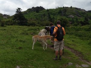
Dogs: Not Allowed
Difficulty: Moderate to Strenuous
Permit Required? Yes – $35 National Park Entry Fee or Annual Pass Plus Timed Entry Permit (Beginning 2024, Follow this Link for Details)
Considerations: Small Trailhead, Bears, Snow, Rocky Terrain
Season: Summer – Early Fall
Overview
Hike a portion of the famous Wonderland Trail in Mount Rainier National Park known as the Summerland Trail and experience the incredible beauty and diversity of mighty Mount Rainier on the way to Panhandle Gap .
MOUNT RAINIER
The tallest of the volcanic peaks in the Cascade Mountain Range, magnificent Mount Rainier soars 14,410 feet above sea level and has 25 major glaciers – more than any other mountain in the continental United States. Mount Rainier gets a lot of snow, and it often lingers well into the summer at higher elevations. Access to Mount Rainier is therefore limited once the snow arrives, and it remains that way until it melts sufficiently for the roads and trails to be travelled safely.
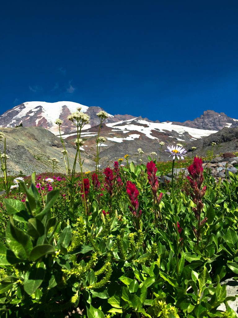
At lower elevations the snow melt occurs much earlier, and access to the roads and hiking trails becomes possible. As the snow melts, the brilliant mosses and wildflowers that call Mount Rainier home awaken, decorating the mountain and its surrounds with glorious color. Once this happens, nature lovers and hikers flock to the trails around Mount Rainier to see and experience its incredible beauty.
SUMMERLAND TRAIL
The Summerland Trail is a very popular hiking segment of the famous Wonderland Trail. Because it is shared with backpackers who hike and camp along the Wonderland Trail as they circle the entire mountain in one epic trip, the Summerland section of the trail gets quite busy in the summer.
The Summerland Trail starts off with little in the way of elevation gain, making the start of the hike a pleasant stroll through the forest. It then climbs steadily, but mostly gradually, through the trees. Hikers will encounter several stream crossings, but will otherwise not see much beyond the lovely forest. When the trail takes a short break from tree cover after about 3.5 miles it is to roll briefly through a meadow area just below the switchbacks that finally deposit hikers at the meadows of Summerland.
Summerland Meadows
Summerland is special. Its meadows are exquisite, and the views are outstanding. After climbing roughly 2,000 feet over 4.5 miles, mostly in the trees, Summerland is a picture perfect place to take a break and enjoy the scenery. In fact, the meadows here are so pretty that they are the final destination for many day hikers. After exploring these flowery meadows laced with small streams out to the far edge of the meadows, these hikers turn around and head back to the trailhead. However, others who are ready to tackle more adventure understand that continuing on has great rewards.
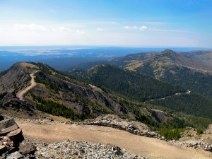
PANHANDLE GAP
The final destination for day hikers on the Summerland Trail who are ready for more adventure is Panhandle Gap. The end of Summerland meadows where the lush vegetation disappears makes it appear it is not worth going on because the trail turns from dirt to rock. This assessment is incorrect. It is absolutely worth continuing. Over the next 1.5 miles hikers get to experience much more adventure as they follow cairns and a trail of worn rocks (sometimes lined with other rocks) through boulder fields as they ascend to Panhandle Gap.
A Rocky Landscape
Though it seems implausible, this rocky, desolate terrain is exquisite! Crystal clear water streams down through jumbled rock, and dazzling aqua blue tarns and brilliant patches of white snow provide both color and contrast in this desolate rock landscape. With an environment devoid of trees, hikers are treated to captivating views of Mount Rainier’s snow capped summit silently looming in the distance. Those who go know why hiking up to Panhandle Gap is 100% worth the effort. It is breathtakingly beautiful.
FRAGILE FOLIAGE
We would be remiss if we did not point out the conservation efforts we can all help with on Mount Rainier. Because it gets both day hikers and backpackers, the meadows of Summerland endure a lot of foot traffic. Since the beautiful mosses and flowers here are easily destroyed by footsteps, hikers and backpackers are asked to stay on existing footpaths. Doing so in the camping area and throughout the meadows preserves and protects the unique beauty of this special place for future adventurers to enjoy. If you go here, take lots of pictures, but leave only footprints… on the trail.
Scroll down to learn about the GEAR WE USE and OTHER OUTVENTURES in this area.
Additional Information (Click below to follow links.)
Summerland Trail & Panhandle Gap Slideshow
(Click image to expand.)
Gear We Use for Day Hiking
To see descriptions of the gear Chris & Mac use for day hiking, as well as links to manufacturers and retailers offering the gear for sale, please CLICK HERE.
Articles About Other Regional Outventures
SAFETY DISCLAIMER: The activities discussed in this website are outdoor activities and, as such, have inherent risks to which participants are exposed. It is not the intent of this website, nor is it possible due to the variability of weather, terrain, equipment, and experience, to detail all of those risks. The information contained in this site is informational, but not instructive nor exhaustive. It is the sole responsibility of the user to ensure he/she is in good health, fully prepared, and fully informed as to dangers before undertaking any of the activities discussed in this website and the user does so at his/her own risk. The user understands that by using this website he/she acknowledges and accepts all risks associated with use of information from this website and participation in any particular activity addressed herein. Please see “Terms of Use” for additional information.
Want to share this article with your friends? Click on the share button below:
Want more?
Get the latest outventure updates by following us on social media . . .