Hiking up Avalanche Gulch on Mount Shasta is an excellent adventure with mind blowing views, incredible scenery, and often a lot of snow too.

Chris & Mac
We outventure to help you outventure!
For us, outventuring isn’t just about adventure. It’s about the quiet moments — the first light on a ridgeline, the sound of a creek at camp, the shared laughter when the trail gets spicy. We believe the outdoors enriches people’s lives, and we want to help more folks experience that connection. Learn more about us HERE.
Scroll down for full slideshow.
Length: 11 Miles Round Trip to Summit
Trailhead(s): Bunny Flat Trailhead
Elevation Gain: 7,200’ Maximum to Summit
Trail Type: Out & Back
Dogs: Not Allowed in Mount Shasta Wilderness or Sierra Club Foundation Property
Difficulty: Moderate to Strenuous
Permit Required? No
Considerations: Snow
Season: Year Round
Overview
Hiking up Avalanche Gulch on Mount Shasta is an excellent adventure with mind blowing views, incredible scenery, and often a lot of snow too.
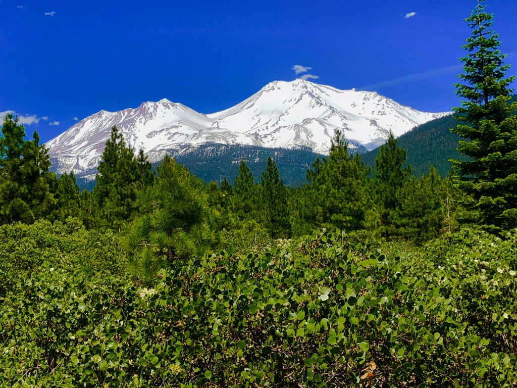
MOUNT SHASTA
Mount Shasta is one of the prettiest mountains in the Cascade Range, and I never tire of looking at it. At 14,179 feet tall, it is only 232 feet shy of Mount Rainier which is the tallest in this range. Like Mount Rainier, it never sheds all of its snow, and it is big. It is so big because of the four dormant volcanic cones which form this massive mountain. Its satellite cone, Shastina, is tall too, rising over 12,000 feet.
With so much area to spread out and explore, Mount Shasta is an outdoor adventurers paradise. It has grand adventures, grand landscapes, and grand views. As such, hikers, backpackers, skiers, and mountaineers alike venture to Mount Shasta for their adventures all year long.
Although this big mountain has many areas of Mount Shasta to explore, one of the most popular areas which gets lots of visitors, particularly in the summer, is Avalanche Gulch.
AVALANCHE GULCH
Avalanche Gulch is popular because it is the easiest and most direct route to the summit of Mount Shasta. In early summer, backcountry skiers and snowboarders head to the Bunny Flat Trailhead because Avalanche Gulch often still has snow. Because the snow is less, however, this is also when backpackers and mountaineers make their way up to the summit, and day hikers explore further down.
The Route
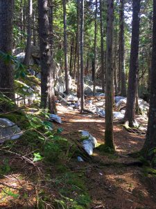
Follow the Avalanche Gulch / John Muir route up for as far as you care to hike. The trail initially starts off towards a ridge of trees in an open meadow. It makes a hard left when it reaches the trees and moves to the other side of them. The trail essentially just climbs and climbs, and it gets steeper as it ascends. When there is snow, the way up follows the natural terrain. Once the snow melts off, however, there is a maintained trail up to Horse Camp. After that, a stone “causeway” with steep switchbacks is in store for those determined to go higher.
Snowy Avalanche Gulch
When we visited Mount Shasta in early June, Avalanche Gulch was filled with snow. It was plentiful and deep, so we donned our snowshoes for this hike. Even though there was deep snow at the trailhead the air was warm. This made our long sleeve shirts comfortable at first, but not for long. Since we knew it would get colder as we ascended we stuffed additional layers and jackets into our packs. We did not get very far before pulling them out and putting them on.
We saw many people having fun in Avalanche Gulch. It was a gloriously beautiful, sunny day. Consequently, all activities were a go. Some folks (like us) were snowshoeing, but most were skinning up and then skiing or snowboarding back down. Others were carrying heavy packs because they were hiking up to camp and/or summit Mount Shasta. It was amusing to watch some of those who had camped up above descend. They were sliding down on their sleeping pads.
Why slide? Because the warm sun softens the snow as the day progresses. Walking through it is very difficult – even in snowshoes. Those who had hiked up when the snow was firm had different conditions for their return to Bunny Flat Trailhead. Because their boots now sank deeply into the soft snow, sliding was their best option for a safe descent.
Short of Our Goal
Although we had hoped to make it up to Lake Helen, the snow in Avalanche Gulch was getting softer by the minute. It was already difficult to walk, and we were barely above the Horse Camp. Watching others above us laboring hard to descend though the quickly softening snow, we decided to halt our forward progress up Avalanche Gulch. In total, we hiked up just over 2 miles and climbed 1,426 feet. This little four mile round trip wasn’t easy, however. It took us over 5 hours.
Disappointed that safety and comfort concerns cause us to stop short of our goal, we take solace in the breathtaking views. Changing our plans based on the conditions we encounter is something we will do when it is prudent. This was one of those times.
As such, we stop for lunch on a small rock outcropping before heading back down. From here we observe a beautiful rocky ridge above us, and the views looking out are phenomenal. The sun is warm, and we are comfortable and content. We pull the rain covers for our packs out to sit on. They make perfect barriers between our rears and the snow, and we stay dry.
Slip Sliding Back Down Avalanche Gulch
As we begin descending we immediately understand why we saw people sliding rather than walking back down Avalanche Gulch. Although the softening snow made going up hard, we discover that going down the steep slope here is even worse. In the mushy snow the excellent teeth on our snowshoes have nothing to grip, and they just slide.
Since keeping our toes pointed downward sends us skidding, we turn our bodies sideways and resort to sidestepping. This method keeps us on our feet, and we slowly descend Avalanche Gulch. Once we get down to just above the tree line we can walk normally again because Avalanche Gulch is less steep here.
Despite the soft snow we encountered, our snowshoe up and down Avalanche Gulch was a blast and we’d do it again in a heartbeat. Outventure on!
Scroll down to learn about the GEAR WE USE and OTHER OUTVENTURES in this area.
Additional Information (Click below to follow links.)
- National Park Service Information Link
Avalanche Gulch Slideshow
(Click image to expand.)
Gear We Use for Day Hiking
To see descriptions of the gear Chris & Mac use for day hiking, as well as links to manufacturers and retailers offering the gear for sale, please CLICK HERE.
Articles About Other Regional Outventures
SAFETY DISCLAIMER: The activities discussed in this website are outdoor activities and, as such, have inherent risks to which participants are exposed. It is not the intent of this website, nor is it possible due to the variability of weather, terrain, equipment, and experience, to detail all of those risks. The information contained in this site is informational, but not instructive nor exhaustive. It is the sole responsibility of the user to ensure he/she is in good health, fully prepared, and fully informed as to dangers before undertaking any of the activities discussed in this website and the user does so at his/her own risk. The user understands that by using this website he/she acknowledges and accepts all risks associated with use of information from this website and participation in any particular activity addressed herein. Please see “Terms of Use” for additional information.
Want to share this article with your friends? Click on the share button below:
Want more?
Get the latest outventure updates by following us on social media . . .