The West Eagle Loop in the beautiful Wallowa Mountains offers greater solitude but all the beauty of the more traveled backpacking routes.

Chris & Mac
We outventure to help you outventure!
For us, outventuring isn’t just about adventure. It’s about the quiet moments — the first light on a ridgeline, the sound of a creek at camp, the shared laughter when the trail gets spicy. We believe the outdoors enriches people’s lives, and we want to help more folks experience that connection. Learn more about us HERE.
Scroll down for full slideshow.
Length: 33.8 miles
Trailhead(s): West Eagle Trailhead
Elevation Gain: 7,512’
Trail Type: Lollipop
Dogs: Allowed
Difficulty: Moderate to Difficult
Permit Required? Yes; Free Wilderness Permit – Self Issue at Trailhead
Considerations: Snow May Linger Into July; The Wallowas can be quite rugged and remote, so it’s important to pack light, bring only the essentials, and have proper safety gear.
Season: Summer & Early Fall
Overview
The Wallowa Mountains in northeastern Oregon are a stunning and relatively undiscovered backpacking destination. With jagged peaks, crystal-clear lakes, and miles of wildflower-filled meadows, the Wallowas offer some of the most scenic backpacking trails in the Pacific Northwest. Of the many backpacking routes, one could take in the Wallowas, the West Eagle Loop (which is really a lollipop loop) is one not to be missed.
Day 1 of West Eagle Loop: West Eagle Trailhead to Diamond Lake – 9.25 Miles
Leaving the West Eagle Trailhead, we hiked the West Eagle Trail to the junction with the Tombstone Lake Trail. We followed the Tombstone Lake Trail to the west past Tombstone Lake to Diamond Lake. It was a great hike with views the entire day. The trails ascended all day and seemed to offer additional climbing around each corner, making the climb feel endless. That said, the trails were well switched so the climb was not too strenuous.
Tombstone Lake is a beautiful lake and worth spending some time to have a bite to eat. Diamond Lake is also very pretty, but we found no way to get down to the lake due to the mostly sheer drops to the water.
At Diamond Lake, we found a side trail which took us to a couple of previously used campsites. The furthest campsite had some water with a small flow, so we chose to camp there for the night. It provided a beautiful view of Diamond Lake to enjoy before bed and upon rising in the morning.
Day 2 of West Eagle Loop: Diamond Lake to Minam River Campsite – 10.7 Miles
The first 2-2.5 miles were very scenic and rocky, but it was an easy descent. By time we hit the junction of Tombstone Lake Trail and the Elk Creek Trail, we were hiking mostly in woods. The woods were, however, fairly open and pretty. Traveling the Elk Creek Trail, we had to make many creek and a few river crossings. These crossings would be significant in the early summer, but in fall they were easily manageable.
As we continued, we traveled through numerous, but brief, burn areas (fortunately they were not ugly burn scars) and a few meadows. When we first reached the Minam River, we saw some good campsites, but wanted to push further. Just past the junction of the Minam River Trail and the Main Eagle Trail we found more campsites and grabbed a great one right next to the Minam River. Above us a little way off, an outfitter had established a hunting camp for some clients in a meadow, but the meadow was large and could accommodate numerous other backpackers if necessary.
Day 3 of Wset Eagle Loop: Minam River Campsite to Echo Lake – 10.9 Miles
From our campsite at the Minam River, we followed the Main Eagle Trail to the West Eagle Trail. This was the beginning of a long ascent to the pass next to Traverse Lake East Peak. The first 1-2 miles were wooded but pretty with interspersed meadows and many downed trees. Then the views started to open more and more.
Eventually we exited the trees at a large meadow and reached the junction with the West Eagle Trail. This trail began the hardest part of the climb, ascending to a pass next to Traverse Lake East Peak. The ascent was beautiful and well switched, with mountains increasingly revealing themselves behind us.
Although the trail was very rocky, the rocks were smooth enough that they caused no problem for our dog’s (Geo) paws. The views as we ascended were incredible and we could see Eagle Cap in the distance as we got higher. We were unable to see the pass, however, until we were right on it.
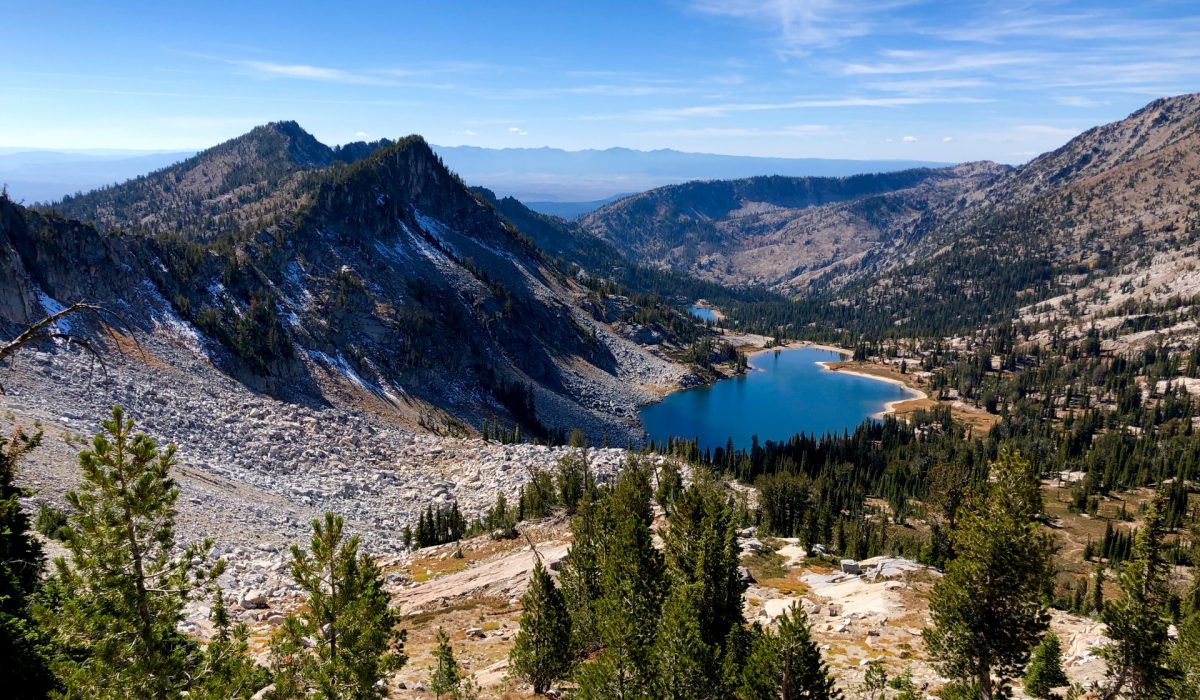
The pass was really just a small cut. When we moved through the cut, it was like entering a completely different area with views that bore no resemblance to what was behind us. The scene was mind blowingly beautiful with Traverse and Echo lakes visible far below.
The descent down to Traverse Lake was deceptively long but very enjoyable. The lake was pretty, although the lake level was down and we could not find any suitable campsites, so we continued to Echo Lake.
From above, Echo looked like it was right next to Traverse but in reality it was at least a mile of additional descent to get to Echo. At Echo, we found campsites in three different areas offering plenty of camping. Poking around a bit, we found an awesome site to spend the night.
Echo Lake, like Traverse, was down considerably, but still pretty. If it had been full, it would have been amazingly beautiful but the low lake level did afford us a fun opportunity to play with Geo on the extended shoreline.
Day 4 of West Eagle Loop: Echo Lake to the West Eagle Trailhead – 6 Miles
The descent from Echo Lake had a lot of switchbacks but the trail was well graded. Going in the reverse, the climb from the trailhead to the pass would be a rigorous climb but still less taxing than coming from the side of the pass we climbed. In total, we descended 1,560’ over 5.93 miles to get to the West Eagle Trailhead from Echo Lake. The descent was fast and pretty. Most of the descent was open and we didn’t really enter any woods until we arrived at the junction of the West Eagle Trail and the Tombstone Lake Trail (the top of the stick in the lollipop). From the junction, it was a quick hike back to the West Eagle Trailhead.
Concluding Thoughts About the West Eagle Loop
Overall, backpacking in the Wallowa Mountains is an unforgettable experience that offers some of the most scenic and challenging trails in the Pacific Northwest. With careful planning, preparation, and respect for the environment, you can enjoy all that this beautiful wilderness has to offer.
There is a ton of trail and scenery to enjoy in the Wallowas, making multiple backpacking trips to explore the mountains worthwhile. When considering your options, make sure the West Eagle Loop is high on your list. The loop is less crowded than some of the other options, but it packs all the beauty that make the Wallowas a must backpack destination. Enjoy!
Scroll down to learn about the GEAR WE USE and OTHER OUTVENTURES in this area.
Additional Information (Click below to follow links.)
West Eagle Loop Slideshow
(Click image to expand.)
Gear We Use for Backpacking
To see descriptions of the gear Chris & Mac use for backpacking, as well as links to manufacturers and retailers offering the gear for sale, please CLICK HERE.

Articles About Other Regional Outventures
SAFETY DISCLAIMER: The activities discussed in this website are outdoor activities and, as such, have inherent risks to which participants are exposed. It is not the intent of this website, nor is it possible due to the variability of weather, terrain, equipment, and experience, to detail all of those risks. The information contained in this site is informational, but not instructive nor exhaustive. It is the sole responsibility of the user to ensure he/she is in good health, fully prepared, and fully informed as to dangers before undertaking any of the activities discussed in this website and the user does so at his/her own risk. The user understands that by using this website he/she acknowledges and accepts all risks associated with use of information from this website and participation in any particular activity addressed herein. Please see “Terms of Use” for additional information.
Want to share this article with your friends? Click on the share button below:
Want more?
Get the latest outventure updates by following us on social media . . .