Length: 17.1 Miles (Shuttle Ride); 22 Miles (with Gravel Road Ride)
Trailhead(s): Paulina Campground
Elevation Gain: 1,782’ (2,899′ Descent) – Shuttle Ride; 3,512′ (3,514′ Descent) – with Gravel Road Ride
Trail Type: Loop
Dogs: Allowed
Difficulty: Very Difficult
Permit Required? No
Considerations: Best Ridden Counter-Clockwise; Loose Shale and Off Camber in Spots; Loop can be Shuttled or Ridden as Whole; $5 Day Use Fee
Season: May – October/November
Overview
Have a blast riding the Crater Rim Trail around a volcano’s caldera with fantastic views of two lakes, a rocky peak, and central Oregon’s Cascade range! (Sorry, couldn’t resist the pun.) But seriously, this is an awesome mountain bike ride around a beautiful volcanic caldera. It requires a good amount of climbing, particularly if you choose not to use a shuttle, but you will be rewarded with amazing views, really buff singletrack, some challenging terrain, and a backcountry experience where you will likely have the whole trail to yourself for most of the ride.
Riding Options
There are two ways to tackle the Crater Rim Trail – shuttle or full loop ride. I recommend a shuttle ride if you have two vehicles. By shuttling, you will save yourself a 3.1 mile, 1,700 foot gravel road climb to the start of the Crater Rim Trail. The ride on the road is simply a slog and, unless you like heavy climbing, you will not miss anything by skipping it.
Trail Overview
Regardless of whether you ride the gravel road or shuttle it, leave the lake parking area in the campground and cross the road to head up FR 500. At about 3.1 miles, near the top, you will see a small sign on the right for Crater Rim Trail 3957. This is your starting point. Form here, you will ride the trail counter-clockwise, which is hands-down the preferred direction for this trail. Now, get ready to have some fun!
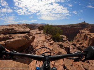
The Crater Rim Trail is easy to follow and has only a few junctions that are well marked. You will start out on some sweet singletrack as you ride the hillside of Paulina Peak. You will climb and descend for some time with great views of the Cascades mountain range before reaching numerous views overlooking Paulina’s two lakes. Eventually, you will come to an area where the trail begins a fun descent. The descent is a little sketchy, as the terrain changes to shale breakdown with off-camber sections, but it is a ton of fun to ride.
At the bottom of the descent you will reach a junction with the Lost Lake Trail. Now begins your next section of climbing. Once at the top of this next section, you will have outstanding views of the lakes and the buff volcanic singletrack that makes central Oregon riding famous. Enjoy your time up here and take some pictures before beginning the final descent.
The final descent is a lot of fun, but there are some pesky water bars to navigate. For those who like to fly, these provide a great opportunity to rip down the mountain. For others who may find them challenging, just take your time. At the end of the water bar section, the trails changes to a forested ride with peaks of Paulina Lake through the trees. This is a really peaceful section of the downhill.
At the bottom of the downhill, you will reach a bridge which you cross. Immediately after the bridge, look for a trail to the campground on the left. Follow this back to you car.
I hope you enjoy this ride as much as I do. Riding the Crater Rim Trail is a unique mountain bike ride and one you will not soon forget. Enjoy!
Scroll down to learn about the GEAR WE USE and OTHER OUTVENTURES in this area.
Additional Information
- Trailforks Interactive Trail Map Link:
https://www.trailforks.com/route/newberry-crater-including-road-climb
- National Park Service Information:
https://www.fs.usda.gov/recarea/deschutes/recreation/bicycling/recarea/?recid=38336&actid=24