Hiking the Burroughs Mountain Loop in Mount Rainer National Park offers up impressive views of mighty Mount Rainier.

Chris & Mac
We outventure to help you outventure!
For us, outventuring isn’t just about adventure. It’s about the quiet moments — the first light on a ridgeline, the sound of a creek at camp, the shared laughter when the trail gets spicy. We believe the outdoors enriches people’s lives, and we want to help more folks experience that connection. Learn more about us HERE.
Scroll down for full slideshow.
Length: 6.3 Miles
Trailhead(s): Sunrise Visitor Center
Elevation Gain: 1,700’
Trail Type: Loop
Dogs: Not Allowed
Difficulty: Moderate
Permit Required? Yes – $35 National Park Entry Fee or Annual Pass Plus Timed Entry Permit (Beginning 2024, Follow this Link for Details)
Considerations: Snow
Season: Summer – Early Fall
Overview
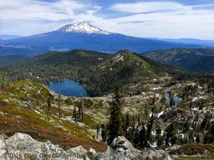
Hiking the Burroughs Mountain Loop in Mount Rainer National Park takes hikers on a beautiful journey that offers up incredibly impressive views of mighty Mount Rainier.
MOUNT RAINIER
At 14,410 feet above sea level, Mount Rainier is not only the tallest of the volcanic peaks in the Cascade Mountain Range, it has 25 major glaciers. This is more than any other mountain in the continental United States. Because Mount Rainier is so tall it gets a lot of snow that often lingers well into the summer, especially at higher elevations like the Paradise Visitor Center which sits at an elevation of 6,400 feet. Access to this area is therefore limited once the snow arrives, and it remains that way until it melts sufficiently for the road to the visitor center to be travelled safely. Even though roads may be open, however, hikers are advised that there may still be significant snow on the trails even when the roads are open.
BURROUGHS MOUNTAIN
Burroughs Mountain has not one, but three summits – First Burroughs, Second Burroughs, and Third Burroughs. First Burroughs tops out at 7,160 feet in elevation, Second Burroughs at 7,400 feet and Third Burroughs rises 7,828 feet above sea level. While this mountain lacks the lush vegetation found at lower elevations around Mount Rainier, its unique rocky plateau features an alpine tundra typically found only at much higher elevations.
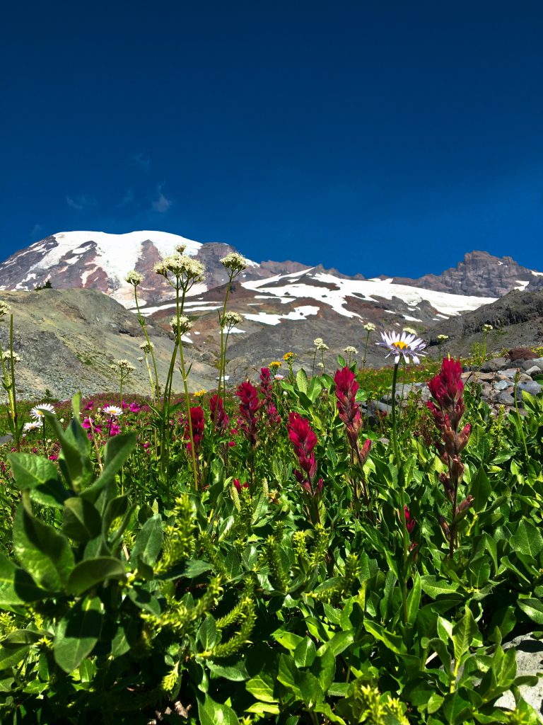
Surprisingly, the rough and scrubby landscape of Burroughs Mountain is filled with life. Despite its barren appearance, Burroughs Mountain has a wide variety of vegetation that offers a pretty wildflower display in the early summer. Dwarf Lupine, Tundra Aster, Lutkea, Davis’ Knotweed, Alpine Yellow Fleabane, and numerous varieties of sedges and Saxifraga all thrive here. Besides the vegetation which firmly cements itself in this rocky landscape, Burroughs Mountain is also home to some wildlife as well. Pikas, chipmunks, and marmot scurry around the rocks, and herds of goats graze on the hillsides.
From the three summits of Burroughs Mountain the views of Mount Rainier, Little Tahoma Peak, and the Emmons, Winthrop, Inter, and Fryingpan Glaciers are incredible. These views, as well as the unique vegetation and interesting wildlife, are why hiking the Burroughs Mountain Loop is so popular on Mount Rainier.
Burroughs Mountain Loop Hike
⇔ Which Direction?
This loop can be hiked clockwise by starting off on the Sunrise Rim Trail, but hiking the Burroughs Mountain Loop counterclockwise has generally less strenuous ascents. To hike counterclockwise, take the path leading up from the northeast corner of the parking area up to Sourdough Ridge. Then head towards Frozen Lake on the Sourdough Ridge Trail about a mile and a quarter to where it intersects with the Burroughs Mountain Trail. The Wonderland Trail also passes through this intersection as does the trail leading to the Mount Freemont Lookout, so be sure to get on the right trail at this marked intersection.
⇒ First Burroughs
Summit the flat top of First Burroughs after climbing up about .7 miles on the Burroughs Mountain Trail. This stretch of the trail as it climbs steadily is a great area to look for goats grazing on the hills below. Once at First Burroughs note that the trail splits – one way loops back and the other leads further out. If this is your destination, head back in either direction. If continuing on, the way out to Second Burroughs is clear – just continue straight along the exposed trail for another .6 miles.
⇒ Second Burroughs
The rocky summit of Second Burroughs moves most hikers to just drop their packs and call it done. The views from Second Burroughs are mind blowing and phenomenal. So go ahead – do as we did and simply sit, mouth open, to stare at the view. That is what everyone here does – at least for awhile. Even those who do continue the additional mile and a half out to Third Burroughs take some time to linger here. We did not go past Second Burroughs, so when we were ready to leave we simply turned around and headed back toward First Burroughs.
⇔ Loop It
To make this hike a loop, bear right on the Burroughs Mountain Trail where it splits at First Burroughs. It is a little further back this way, but this way offers up more excellent hiking and viewing. After 1.3 miles the Burroughs Mountain Trail ends at the trail up to Sunrise Camp near Shadow Lake. At this point switch to The Wonderland Trail and follow it up to the Sunrise Rim Trail to get back to the parking area.
We were absolutely thrilled at all we saw while hiking the Burroughs Mountain Loop, and think you will be too. If you are visiting Mount Rainier National Park, put this hike on your “to-do” list.
Scroll down to learn about the GEAR WE USE and OTHER OUTVENTURES in this area.
Additional Information (Click below to follow links.)
Burroughs Mountain Loop Slideshow
(Click image to expand.)
Gear We Use for Day Hiking
To see descriptions of the gear Chris & Mac use for day hiking, as well as links to manufacturers and retailers offering the gear for sale, please CLICK HERE.
Articles About Other Regional Outventures
SAFETY DISCLAIMER: The activities discussed in this website are outdoor activities and, as such, have inherent risks to which participants are exposed. It is not the intent of this website, nor is it possible due to the variability of weather, terrain, equipment, and experience, to detail all of those risks. The information contained in this site is informational, but not instructive nor exhaustive. It is the sole responsibility of the user to ensure he/she is in good health, fully prepared, and fully informed as to dangers before undertaking any of the activities discussed in this website and the user does so at his/her own risk. The user understands that by using this website he/she acknowledges and accepts all risks associated with use of information from this website and participation in any particular activity addressed herein. Please see “Terms of Use” for additional information.
Want to share this article with your friends? Click on the share button below:
Want more?
Get the latest outventure updates by following us on social media . . .