The hike to Goat Lake in Idaho’s Sawtooth Mountains has breathtaking views which are worthy of the effort to get there.

Chris & Mac
We outventure to help you outventure!
For us, outventuring isn’t just about adventure. It’s about the quiet moments — the first light on a ridgeline, the sound of a creek at camp, the shared laughter when the trail gets spicy. We believe the outdoors enriches people’s lives, and we want to help more folks experience that connection. Learn more about us HERE.
Scroll down for full slideshow.
Length: 8 Miles Round Trip
Trailhead(s): Iron Creek Trailhead
Elevation Gain: 1,780’
Trail Type: Out & Back
Dogs: Allowed
Difficulty: Moderate to Strenuous
Permit Required? Yes; Self Registration at Trailhead
Considerations: Unmarked Trail, Snow
Season: July-September (Best)
Overview
Hiking to Idaho’s Goat Lake is a bucket list adventure. Why? Because the views from the trail are incredible, the lake is drop dead gorgeous, and the journey includes route finding and rock scrambles. For those who want an exceptional hiking adventure in the Sawtooth’s, this one delivers.
IRON CREEK TRAILHEAD
There is a small campground at the Iron Creek Trailhead. It has toilets, drinking water, and nine campsites. It makes an excellent base camp for this hike and it is first come, first serve. Click here for National Forest Service information on the campground.
Because Goat Lake lies in the Sawtooth Wilderness, a wilderness permit is required for this hike. The permit is free, and self-registration is conveniently located at the trailhead. Additionally, hikers making this journey should note that the Goat Lake Trail is not marked, and the final way up to the lake is not clearly identified. As such, a GPS tracking app like GAIA is especially helpful for this hike.
IRON CREEK TRAILHEAD TO GOAT LAKE
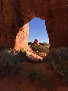
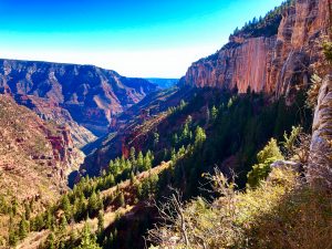
Even though it is only four miles each way, Goat Lake is a special place that takes some effort to reach. As such, get an early start and plan to spend the entire day to get the most enjoyment out of your hike to Goat Lake. You will stop frequently along the trail to appreciate what you are seeing, and you will want to linger a bit at the breathtakingly beautiful lake. This hike has everything we love: babbling creeks, views of jagged peaks, majestic trees, summer wildflowers, a waterfall, and an insanely exquisite and pristine alpine lake.
Iron Creek Trailhead to Alpine Way Trail
Departing from the Iron Creek Trailhead, the rock and root strewn Iron Creek Stanley Lake Trail #640 ascends gently through a pleasant forest. Following Iron Creek through a pleasant valley, the forest opens periodically to tantalize hikers with views of jagged peaks. In the heat of summer, however, the tree cover is especially welcome. The trail reaches the Sawtooth Wilderness boundary 1.1 miles from the trailhead, and soon thereafter intersects the Alpine Way Trail. The junction is marked. Head left on the Alpine Way Trail.
Alpine Way Trail to Goat Lake Trail
The Alpine Way Trail crosses Iron Creek almost immediately after the marked junction with the Iron Creek Stanley Lake Trail #640. The gently ascending trail soon turns steeper, climbing about 450 feet following a small bridge crossing. As you ascend, turn around periodically because the views behind you are stunning. Once it levels off again about two and a half miles from the trailhead, the trail has only minor elevation changes over the next mile.
Goat Lake Trail to Goat Lake
At approximately 3.25 miles the Alpine Way Trail intersects the Goat Lake Trail. The junction is not marked. Head to the right to get on the Goat Lake Trail. After about a quarter mile encounter the final 700 feet of climbing – up the rock wall on the right. The way up is not marked. The hike is more strenuous now due to elevation, exposure, and a lot of scree and rock on a steep slope. It is 100% an adventure to make this scramble, so take care, take your time, keep smiling, and embrace the challenge.
At the top of the rock and scree climb is a huge boulder field. The path of least resistance is toward the stream and trees you see above and to the left. There is a stream crossing above the falls through the trees, and a trail which leads to the shore of Goat Lake.
GOAT LAKE
The clear, cold, blue waters of Goat Lake are mesmerizing. The trail meanders to the left along the near side of the lake. For most, the journey ends with finding an unoccupied area of rock somewhere around the lake to just sit and stare while resting and refueling with lunch or a snack. It is possible to reach the lake for a foot soak or a quick dip in the cold water, if desired.
When ready to return to the trailhead, simply head back the way you came. We found it was much easier to identify the route down the rock and scree field, and our trekking poles were especially helpful for this descent.
Scroll down to learn about the GEAR WE USE and OTHER OUTVENTURES in this area.
Additional Information (Click below to follow links.)
Hike to Goat Lake Slideshow
(Click image to expand.)
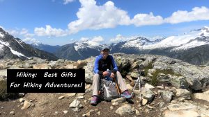
Gear We Use for Day Hiking
To see descriptions of the gear Chris & Mac use for day hiking, as well as links to manufacturers and retailers offering the gear for sale, please CLICK HERE.

Articles About Other Regional Outventures
SAFETY DISCLAIMER: The activities discussed in this website are outdoor activities and, as such, have inherent risks to which participants are exposed. It is not the intent of this website, nor is it possible due to the variability of weather, terrain, equipment, and experience, to detail all of those risks. The information contained in this site is informational, but not instructive nor exhaustive. It is the sole responsibility of the user to ensure he/she is in good health, fully prepared, and fully informed as to dangers before undertaking any of the activities discussed in this website and the user does so at his/her own risk. The user understands that by using this website he/she acknowledges and accepts all risks associated with use of information from this website and participation in any particular activity addressed herein. Please see “Terms of Use” for additional information.
Want to share this article with your friends? Click on the share button below:
Want more?
Get the latest outventure updates by following us on social media . . .