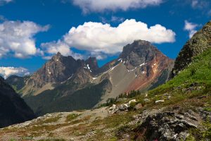
Grandfather Mountain in North Carolina’s Blue Ridge Mountains is a fantastic place to hike. In fact, it is my favorite mountain east of the Mississippi.

Chris & Mac
We outventure to help you outventure!
For us, outventuring isn’t just about adventure. It’s about the quiet moments — the first light on a ridgeline, the sound of a creek at camp, the shared laughter when the trail gets spicy. We believe the outdoors enriches people’s lives, and we want to help more folks experience that connection. Learn more about us HERE.
Scroll down for full slideshow.
Length: Varies Based on Trail Selection and Route
Trailhead(s): Multiple – Boone’s Fork Trailhead, Profile Trail Trailhead, Attraction Area
Elevation Gain: Varies Dependent on Trail and Route Selection
Trail Type: Point to Point or Circuit
Dogs: Allowed in Backcountry, Must be Leashed
Difficulty: Easy to Advanced, Depending on Trail
Permit Required? Yes, Free Self-Issue at State Park Trailheads
Considerations: Bears, Cable and Ladder Use Required on Some Trails, $22 Adult/$9 Child Fee Required to Access Attraction Area
Season: Year Round – Spring, Summer, Fall Preferred
Overview
Grandfather Mountain in North Carolina’s Blue Ridge Mountains is a fantastic place to hike. In fact, it is my favorite mountain east of the Mississippi. Although a very small part of the mountain is a non-profit owned attraction, the mountain is large and the backcountry side, which is a state park and vastly larger than the attraction area, has a good deal of hiking. The combination of these two areas offers visitors the option of family friendly hikes and attractions or backcountry hiking adventures. For those who are particularly ambitious, you can have both. All of this makes Grandfather Mountain a unique hiking destination and one you should not miss if you are visiting western North Carolina.
What Makes Grandfather Mountain Special?
I wish I had an easy answer for this question. To me, it is the “feel” of the Mountain. There is a particular scent that forms from the combination of the pines, the damp soil, and the dry granite that covers the mountain. Add to this the excitement of the attraction area with its Mile High Swinging Bridge and events such as the Grandfather Mountain Highland Games. Throw in the fun of navigating ladders, cables, and rock scrambles. Then top it off with the rugged, raw beauty of this fantastic mountain. Grandfather Mountain is a truly unique place and one I think most people will enjoy, regardless how they choose to visit it.
The Approach of this Article
Grandfather Mountain is big and all of it’s trails are worth hiking (which I have done). Because there are so many options here, I debated whether to break Grandfather into multiple articles or just address it in one. I decided that the best resource for our followers would be if I wrote one article breaking the discussion down by area and main trails, which is what follows. Note that the slide show at the bottom of this post follows the order of presentation of the article. To make it easy to follow, I start each section of the slide show with a picture of a sign marking the respective trail.
State Park Backcountry Area
Nuwati & Cragway Trails
From the Boone Fork Parking Area on the Blue Ridge Parkway, you can access both the Daniel Boone Scout Trail and the Nuwati Trail. The lower Daniel Boone Scout Trail is a good trail, but it is somewhat unremarkable. I believe it makes for a much more interesting hike to begin by taking the Nuwati Trail and, after visiting Story Teller’s Rock, backtracking to the Cragway Trail. The hiking along Nuwati is easy, but rocky and rooty. The views from Storyteller’s Rock are beautiful, so make sure to hike all the way to that spot. After visiting Storyteller, backtrack a short way until you reach the Cragway Trail, which will give you a taste of the adventurous hiking to come as you ascend Grandfather Mountain.
The Cragway Trail is steep, but great for adventure. You will encounter technical trail, rock scrambles, and some amazing views at Top Crag and Flat Rock. Although somewhat strenuous, the fun of the boulderous terrain and the beauty of the views are a great pay-off for the effort. Having hiked Daniel Boone from the bottom, as well as Nuwati and Cragway to where Cragway meets Daniel Boone about a third of the way up to Calloway Peak, I think Nuwati/Cragway is the best way to hike up this side of Grandfather Mountain.
Daniel Boone Scout Trail
As stated in the last section, the Daniel Boone Scout Trail is accessed from the Boone Fork Parking Area. The trails ascends about 2,000 feet over 3 miles until it reaches Calloway Peak at 5,964 feet. Again, as mentioned above, the first half of the trail before it reaches Cragway Trail is pretty, but not very exciting. It is mostly a tree covered woods hike. Once past the Cragway intersection, however, the fun begins.
The upper half of the Daniel Boone is rough and somewhat strenuous, but there are outstanding views of the Blue Ridge range, beautiful craggy, rooty and rocky forest, and some great adventure. The hiking can be slow, as the trail is very rough, but what awaits makes the effort a no-brainer.
Before reaching the end of the trail where Daniel Boone meets the Grandfather Trail, you will reach the Viaduct View, which is a good place for a snack. Don’t eat too much, though, because you will not want to ruin your lunch which I highly recommend you eat at Calloway Peak. The view from the Viaduct viewpoint is sweeping. Sit for a minute or two to soak in the view and get ready for what is next.
Towards the top of the Daniel Boone Scout Trail, just below Calloway Peak, you will encounter ladders and cables that will help you get to the Peak. These may be scary for some, but I have a blast navigating these challenges and they make the adventure all the bigger. (Note that if you bring a dog on your hike, you will have no option but to carry the dog up the ladders or you will not be able to go any further.)
Once you have navigated the ladders and cables, you will have one final push to get to Calloway Peak. The Peak is awesome and the views are outrageous. We always have lunch here and allow ourselves time to enjoy the scenery. Because getting to Calloway is challenging, regardless of how it is accessed, there are rarely more than a couple of people here, so you should have plenty of room to enjoy your lunch. After lunch, we highly recommend you explore at least part of the Grandfather Trail. It is a short backtrack from the Peak to where the Grandfather and Daniel Boone trails intersect.
Grandfather Trail
There are three ways to access the Grandfather Trail. You can access it from the attraction area, but must pay the entrance fee. For free, you can also access it from the Profile Trail or the Daniel Boone Scout Trail. We addressed accessing it from Daniel Boone above and address access from the Profile Trail later in this article. No matter how you get to the trail,don’t miss it. This is hands down the most fun, interesting, technically challenging, and beautiful trail on Grandfather Mountain. It is also one of my favorite trails in the Blue Ridge Mountains.
If you decide to access the Grandfather Trail from the attraction parking area, you will climb for 2.4 miles until reaching Calloway Peak. The trail at the bottom is good and you will soon encounter the first ladders and cables area. Be aware, this area is not for the faint of heart or small children. You will be climbing a rock face using the cables and ladders and the exposure is intimidating. There is one particularly tricky transition from one ladder to another, so be mentally prepared. If you are uncomfortable with the idea of this, you can take the Underwood Trail (discussed below) to avoid this section of the Grandfather Trail. That said, if you are up for an adventure, this one rocks! (Sorry, I had to . . .)
Following the ladders, you will reach McCrae’s Peak. While a bit lower than Calloway Peak (the highest on the mountain), McCrae’s should not be missed. You will have to climb a ladder to get to the top of the peak, but the views are outstanding. Not only are there views of the surrounding Blue Ridge Mountains, but the views of the rocky peaks of Grandfather can not be beat.
After McCrae’s Peak, the Grandfather Trail continues along the spine of Grandfather all the way until it reaches Calloway Peak. Along the trail you will encounter a variety of cool features such as the Attic Window and Indian House Cave. You will also encounter many small ladders, cables, rock scrambles, and boulder climbs. All of this while dancing on what at times, seems like a razor thin spine. I cannot tell you how much fun this is to hike! Of all the areas on this great mountain, this part is absolutely my favorite. Don’t miss it!
Underwood Trail
The Underwood Trail is a short .5 mile trail that will allow you to avoid the ladders and cables on the Grandfather Trail if you are coming from or going to the attraction parking area. Don’t be fooled by the short distance, however, as this trail is slow going. The trail is very rough and strewn with huge rocks and boulders, as well as roots. You will have to navigate a short ladder and cable, but they are by no means as challenging as those on the Grandfather Trail.
Profile Trail
The final way to access Grandfather Mountain is to use the Profile Trail from Highway 105. This trail starts out easy, but becomes much more rigorous as you ascend the mountain. Most of the trail is wooded with limited views. About halfway up, you will reach the Foscoe View. The view is frankly unremarkable, but breaks the monotony of the woods. After the Foscoe View, the trail begins to climb steeply until reaching the next view – the Profile View.
The Profile View is worth the look. It is a neat feature of the mountain, so stop and take a few pictures while you rest for what is next. The trail is about to get quite steep and you will need to climb about 200 steps made of granite slabs as you move higher. At about 2.7 miles, you will hit Shanty Springs. At this point, the trail will become very steep and you will be hiking over jumbled rock falls and roots for the next .3 miles until you reach the intersection with the Grandfather Trail. From here, you can turn left and go just over .1 miles to Calloway Peak or turn right and have fun navigating the spine of the mountain toward McCrae’s Peak – or do both!
Attraction Area and Highland Games
The non-profit attraction area is worth note on Grandfather Mountain because it offers some family friendly fun and a few attractions worth seeing. The area was set-up as a non-profit to teach about the mountain and its preservation. The non-profit was established when the family who owned the Grandfather Mountain donated the majority of the mountain to the State of North Carolina for establishment of a state park.
The highlight of the attraction area for many is the Mile High Swinging Bridge that spans an 80 foot gorge and is . . . a mile high. The area also has a Nature Museum and wildlife habitat, as well as a couple of nature trails, overlooks, and picnic areas.
The attraction area is also the location of the Grandfather Mountain Highland Games, which are held each July. This is a huge gathering of the clans and is a ton of fun, with competitions, concerts, and Celtic pride. If you are in the area while it is going on, make a point of attending.
Conclusion
Grandfather Mountain in North Carolina’s Blue Ridge Mountains is a great place to hike. The mountain is very diverse and offers the opportunity to create any number of outventure experiences, from hard core hiking to family friendly fun. I can’t tell you how much I love this mountain. I am certain if you visit, you will love it too!
Scroll down to learn about the GEAR WE USE and OTHER OUTVENTURES in this area.
Additional Information (Click below to follow link.)
Grandfather Mountain Slideshow
(Click image to expand.)
Gear We Use for Day Hiking
To see descriptions of the gear Chris & Mac use for day hiking, as well as links to manufacturers and retailers offering the gear for sale, please CLICK HERE.
Articles About Other Regional Outventures
SAFETY DISCLAIMER: The activities discussed in this website are outdoor activities and, as such, have inherent risks to which participants are exposed. It is not the intent of this website, nor is it possible due to the variability of weather, terrain, equipment, and experience, to detail all of those risks. The information contained in this site is informational, but not instructive nor exhaustive. It is the sole responsibility of the user to ensure he/she is in good health, fully prepared, and fully informed as to dangers before undertaking any of the activities discussed in this website and the user does so at his/her own risk. The user understands that by using this website he/she acknowledges and accepts all risks associated with use of information from this website and participation in any particular activity addressed herein. Please see “Terms of Use” for additional information.
Want to share this article with your friends? Click on the share button below:
Want more?
Get the latest outventure updates by following us on social media . . .